
The Saginaw Impact Manifold
The Carolina Bays: Medial Ejecta Surface Features
Australasian Tektites: Distal Ejecta
Geophysical Flow Analysis Confirms Relationship & Enables Triangulation To Causal Impact Site
Abstract
We present a novel approach to the genesis of the Carolina bays, proposing that those enigmatic landforms are depositional features within a 1 to 10 meter-thick blanket of hydrated ejecta associated with a cosmic impact into the North American ice shield at the Mid-Pleistocene Transition, ~800,000 years ago. The ellipsoidal bays exhibit an "inferred orientation", facilitating the use of a triangulation network to identify the associated terrestrial impact crater. Attempts by others to triangulate bay orientations to a causal crater may have failed because the ballistic physics and fluid mechanics aspects of an ejecta distribution over a rotating planet were not considered. An analytical model was heuristically developed to generate ejecta emplacement orientations that reflect large-scale geophysical flow effects, and its results were compared to empirically measured bay orientations of 50,000 Carolina bays. Our model's predicted results correlate well with actual bay orientations when an oblique cosmic impact across the Saginaw area of Michigan is considered. The great-circle distances separating the proposed Saginaw impact crater and all identified Carolina bays also correlate well; the bay’s geographic distribution is along an annulus surrounding the proposed crater. These positive correlations suggest that a unique geospatial relationship exists between the proposed impact location and the Carolina bays of North America.
Pleistocene Epoch cosmic impacts have been implicated in the geomorphology of two enigmatic events. Remarkably, in both cases spirited debates remain unsettled after nearly 100 years of extensive research. Consensus opinion holds that the Australasian (AA) tektites are of terrestrial origin despite the failure to locate the putative crater, while a cosmic link to the Carolina bays is considered soundly falsified by the very same lack of a crater. Likely >100 km in diameter, these impacts during geologically recent times should be readily detectable on the Earth’s surface. The improbability that two craters have eluded detection informs a hypothesis that a single impact at ~786 ka generated AA tektites as distal ejecta and Carolina bays as progeny of proximal ejecta. The AA astroblem search is focused on SE Asia despite a strewn field encompassing >30% of the Earth’s surface. This spatial scope implies to us that inter-hemispheric transits should be considered, as does findings that AA tektites were solidified in a vacuum, then ablated on re-entry at ~10 km sec-1. A Coriolis-aware triangulation network operating on the orientations of 44,000 Carolina bays indicates a focus near 43ºN, 84ºW. Referencing the work of Urey and Lin, we propose that a near-tangential strike to the Earth’s limb generated the 150 x 300 km oval depression that excises Saginaw Bay and opens Michigan’s Thumb. That region was likely buried under deep MIS 19 Laurentide ice at 786 ka. Schultz has shown that oblique impacts into continental ice sheets yield non-traditional astroblemes, and multiple glaciations have since reworked this site, making identification more challenging. Hypervelocity gun tests show that oblique impacts produce a vertical plume of ejecta, biased slightly down-range. Ballistic trajectories reflecting such a plume deliver tektites to all AA finds when lofted at ~10 km sec-1 and parameterized with the proposed depression’s location and 222º azimuth. Chemical and isotopic characteristics of AA tektites suggest they were sourced from sandstone and greywacke of Mesozoic age, which is congruent with Michigan Basin strata lost when The Thumb developed. The distribution of proximal ejecta may explain anomalous pulses of regolith in moraines and sediment loading in regional drainage basins recently dated ~800 ka using 10Be/26Al methods.
Inspiration
The inspiration for our conjecture was an observation in the paper The Goldsboro Ridge, an Enigma, by R. B. Daniels, E. E. Gamble and W.H. Wheeler, 1970:The Goldsboro ridge is a unique feature on the Sunderland surface and requires special explanation whatever its origin. It must be either an erosional remnant of a once more extensive sediment or a depositional feature. ...The Goldsboro sand overlies the Sunderland Formation conformably. The contact is always abrupt but there is no evidence of deep channeling, basal coarse material, and evidence of weathering at the contact. Even the Carolina Bays do not disturb the underlying Sunderland materials.... The sand in the bay rim is not different from the Goldsboro sand. Therefore, these Carolina Bays are merely surface features associated with the formation of the ridge.
My Challenge
Given a confident belief that the answers are indeed out there in the sand, we come then to the true shame of the Carolina Bay story: the willingness of the current geophysical research community to tolerate and admit such a profound "mystery" in their midst. I've known respected professional earth scientists to brush off questions about Carolina Bay origin with references to "alien landings" and "giant fish." With prodding, they generally elicit a thin collage of wind and wave theory faintly recalled from their student years. One gets the distinct feeling that the study of Carolina Bay origin is the "crazy aunt in the attic" of the Coastal Plain researcher. And that visiting his dear relative is hardly worth the disturbing consequences. - George Howard
Community Challenge
No one has yet invented an explanation which will fully account for all the facts observed - Douglas Johnson, 1942
Our License
The truth may be puzzling. It may take some work to grapple with. It may be counterintuitive. It may contradict deeply held prejudices. It may not be consonant with what we desperately want to be true. But our preferences do not determine what's true.... Cleverly designed experiments are the key. - Carl Sagan, 1995.
..... We present our Bearing Calculator as a very cleverly designed experiment.Could it really be true???
All truth passes through three stages. First, it is ridiculed. Second, it is violently opposed. Third, it is accepted as being self-evident. - Arthur Schopenhauer
Carolina bays and the AA Tektites Remain Enigmatic after a century of work
The suggestion advanced in this article may appear to many as too hypothetical to deserve the light of day. However, the tektite problem has been, and is, one of the major puzzles to men "who pick up rocks and stop to think" even before the classical paper of Suess of 1900 appeared, and conservative proposals have been found to be inadequate. - H.C. Urey, 1957
Introduction
In his 1942 scholarly examination of numerous then-current hypotheses for the genesis of Carolina bays, Douglas Johnson noted:
No one has yet invented an explanation which will fully account for all the facts observed.
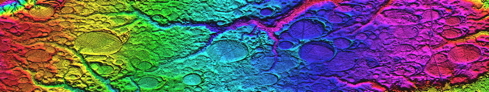
The Carolina bays continue to challenge geological science to this day. Their sheer numbers, distinct oval circumpherial rims, variety of sizes, and common alignments in any one area are enigmatic. Visual photography available since the bays were observed from the air in the early 1930s tells only a part of the story. Digital elevation maps (DEM) created with today’s Laser Imaging and Range Detection (LiDAR) systems accentuates their already-stunning visual presentation. While some of the bay’s characteristics are seen in sand dunes or wind-oriented paleolakes, such comparisons are unsatisfactory to us.
Researchers generally consider the bays to be formed within or excised from pre-existing strata (Prouty, 1952; Eyton & Parkhurst, 1975]. We propose that the bays are surface imperfections within a blanket of ballistically deposited shattered sedimentary strata (sand), generated at time of emplacement by the energetic deflation of steam inclusions. The authors feel this interpretation explains many of the bays’ physical characteristics, such as companion bays at different elevations, occasionally intersecting or overlaying one another. Also explained is a mechanism to create bays on ridges, the ridges themselves being composed of ejecta deposition, which is our interpretation of the Goldsboro Ridge in NC [Daniels, R.B., and E.E. Gamble, 1970].
The lack of a correlated impact structure in North America is problematic for any attempt to implicate a cosmic impact in the genesis of the Carolina bays. Our hypothesis holds that the impacting object was a massive low-density hydrated silicate object, likely a cometary body, which impacted the earth on a shallow angle, nearly tangential to the earth’s surface. Remote sensing has show that approximately 5% of all craters are created during such oblique impacts, creating a set of recognizable characteristics: oval shape, butterfly ejecta pattern, “no-fly” ejecta area up field, and “blow-out” rim down field. [Herrick, R.R, 2009; Herrick R.R. and K. Hessen, 2003]. Recent studies suggest that impacts into solid surfaces protected by a layer of low impedance materials generate structures that differ from the classic crater planforms [Schultz, P. H. and A. M. Stickle, 2009]. In our specific case, we invoke a North American continental ice shield as a low-impedance layer protecting the sedimentary strata of the Michigan basin.
An ejecta curtain wall radiating outward from a cosmic impact should follow a few simple laws of large-scale geophysical flows. We discuss our analytical model engineered to replicate those flows in the Analytical Modeling section.
This web presentation is composed of sections discussing:
- Introduction and Overview
- Unique Characteristics of Oblique Cosmic Impacts
- The Characteristics and Identification of Medial Ejecta
- Analytical Model of Carolina Bay Inferred Orientations
- Survey of Carolina Bay Landforms
- The Saginaw Crater
- Event Timing
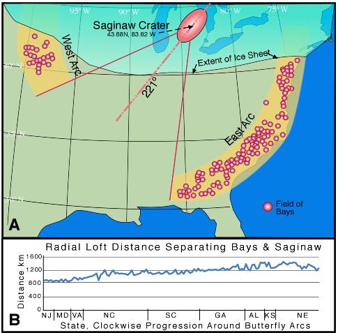
Graphic shows the impact site and triangulation from ~200 bay "fields".