
The Enigmatic Carolina bays
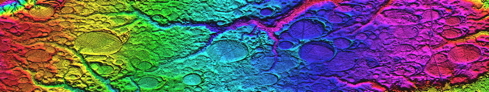
This is one of the early aerial photographs that started the controversy over the origin of the Carolina bays. Certainly, early settlers were somewhat aware of the curious nature of these areas, but until aerial photographs were published, both their consistent oval shape and their vast distribution were unrecognized.
The Saginaw Impact Manifold conjecture suggests that rather than being structures created by impacting extraterrestrial objects, the bays are instead the manifestation of terrestrial ejecta lofted from a distant impact site. We suggest to the reader that in this black & white photograph, the nature of the bays as "splash" structures is apparent. Also apparent is the shape; it is not oval, but more of a tear-drop, with one end being narrower than the other.
Please note that some of the structures display an interesting emplacement artifact. The ejecta sheet involved arrived from the upper left (NNw) in this image. The ejection site is therefore to the north of the emplacement site. The ejecta's velocity has a west-to-east vector component that represents the ground rotation velocity at the ejection site, but the ground here is moving west-to-east at a higher velocity. As a result, the entire emplacement is effectively compressed on the western (left) side. This creates a structure that is not symmetrical across the major axis. This artifact allows for another correlation between an emplaced object and the physics of transporting it to the emplacement site.
Carolina bays are elliptical depressions concentrated along the Atlantic seaboard within coastal Delaware, Maryland, New Jersey, North Carolina, South Carolina, Virginia, Georgia, and north-central Florida (Prouty 1952, Kaczorowski 1977). In Maryland, they are called Maryland basins (Rasmussen and Slaughter 1955). Other landform depressions, not widely accepted as Carolina bays, are found within the northern Gulf of Mexico coastal plain within southeast Mississippi and Alabama where they are known as either Grady ponds or Citronella ponds.
For further visual exploration, the reader is referred to George A. Howard's web site, which offers a wonderful set of arial photographs of Carolina bays.
Carolina bays Interpreted as Depositional Artifacts in a Veneer of Ejecta
While interpretation of the Carolina bays sands as distal ejecta structures would be controversial due to its dependence on a truly incomprehensible deposition of ejecta, the creation of the stylized Carolina bay geometry can easily be seen in the simple paint splatter.
Others have probed and researched the bays and their contents, but those investigations have always considered that the bays were formed within or excised from a hosting strata of sand or gravel which itself was created by well-understood fluvial and eolian deposition. In our interpretation, the region was overlain by a series of 1 to 5 meter thick "sheets" of ejecta slurry from the Saginaw impact ~800,000 years ago. The bays are a surface feature of that veneer of strata. This interpretation helps to explain the creation of bays seen at significantly varying elevation while being quite close to each other, often even overlaying each other. Also explained is a mechanism that could create bays, which exist on hilltops; the hills themselves being composed of emplaced ejecta. This is our interpretation of the structure know as the Goldsboro Ridge in NC.
The Saginaw Impact Manifold Depositional Conjecture holds that a sheet of ejecta debris -a slurry of water and sand/silica - was deposited across a pair of "butterfly" arcs extending our from each side of the impact. The sheet exhibits a surface texture of "popped bubbles" depressions, which have evolved into today's Carolina bays.
We emphasize that our conjecture does NOT suggest that the bays are either primary or secondary impact structures.
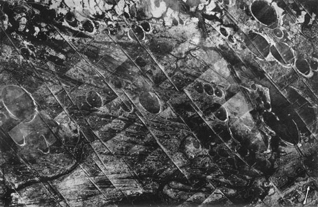
The geomorphic signatures seen in these structures are many, and no other deposition method has been implicated satisfactorily. Arriving from the upper left in these images, the sheet of debris slammed into the terrain, and spread across areas of varying elevation. Within a few hundreds of meters, we see Carolina bays created at significantly different elevations - up to 50 meters variation - as well as having them overlaid and/or partially obscured by additional material arriving moments later. With an incoming velocity of 3,000 km/hour, the slurry surged forward at impact and crated slightly higher rims on the SE end of the splash bay. The ground speed difference effect driven by the latitude delta between the Saginaw ejection point and the deposition location would have added an west-to-east velocity component of hundreds of m/sec. This component would be expected to distort the surficial bay features along the E-W axis, which has been reported: "Many bays, however, lack true bilateral symmetry along either the major or minor axis. ….the northeast side bulges slightly more than the southwest side. (1)
Other supportive details include the well-understood fact that, universally, the soil layers containing the bays are superimposed on underlying strata at a sharp and "abrupt comfortable" interface that shows no inter-bedding. Much of the current research identifies the strata as consistent across wide areas, both within single and multiple bays.
No variation in the heavy mineral suite was found along a traverse of the major axis of one South Carolina bay; even though samples were taken from the bay floor, bay rim and the adjacent non-bay terrace. (Preston and Brown, 1964).
When presented with the ejecta strata concept in 2006, noted soil geologist R.B. Daniels observed that the conjecture, while hard to embrace, did address one ongoing enigma of the bays (and Goldsboro Ridge in particular): The unconsolidated deposits that constituted the rim bays did not contain the lenses of clay that would be expected in a classical fluvial deposition mechanisms.
We created an initial catalogue of ~170 "Fields" of Carolina bay structures. Using the facilities of Google Earth, these sites have been analyzed heuristically to test for geographic association with the proposed Michigan area impacts. In our opinion, the alignment is highly supportive of the conjecture. Subsequent to the initial “field” survey prior to 2010, a more extensive ongoing survey is being conducted and has catalogued over 45,000 individual bay structures to date. See Carolina Bay Survey.
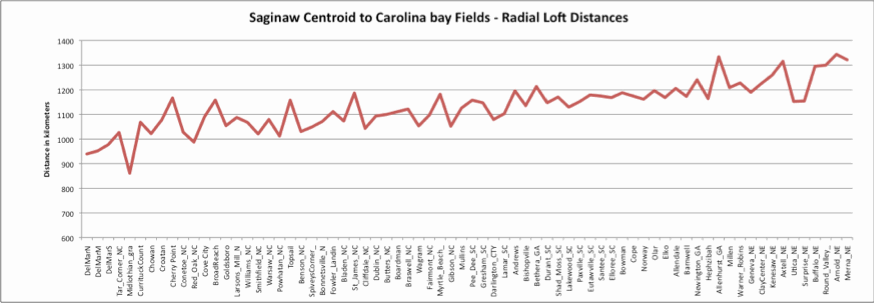
We compared the geographic distance between the proposed crater centroid (@~8min loft time) and each of the evaluated Carolina bay fields. The resulting chart shows a strong correlation between all these sites, both east and west of the proposed crater.. Also relevant is a general trend at increased distances as the sites trend towards the downrange-impact trajectory direction.
Other Explanations
There exists an extensive body of work attempting to identify the natural process responsible for creating the anomalous landforms known as “Carolina bays”, Vernal pools or ephemeral pools. Some of the hypotheses suggested for the formation of the bays are listed by Price (1968a, p. 103):- Spring basins
- Sandbar dams of drowned valleys
- Depressions dammed by giant sand ripples
- Craters from a meteor swarm
- Submarine scour by eddies, currents, or undertow
- Segmentation of lagoons and formation of crescentic keys
- Lakes in sand elongated in the direction of maximum wind velocity
- Solution depressions, with wind-drift sand forming the rims
- Solution depressions, with magnetic highs near bays due to redeposition of iron compounds leached from basins
- Basins scoured out by confined gyroscopic eddies
- Solution basins of artesian springs with lee dunes
- Fish nests made by giant schools of fish waving their fins in unison
- Eolian blowouts (deflation)
Easily identified by their characteristic elliptical shape, these small lakes in the eastern US have frequently been evaluated for a wide range of impact characteristics. They have proven to be inconsistent with landforms formed in situ by a foreign impactor.
Carolina Bays do not even closely approximate impact crater morphometric characteristics. The rim widths appear to be the only measure which even falls within the range predicted by the impact model. In an attempt to examine this phenomenon, a curve relating rim height and rim width was derived from Baldwin's curves and the values for the bays in Table 5 were plotted (Figure 3b). For an impact crater to have a rim height of 7.5 feet, it should have a rim width of 100 feet.
Junkyard Bay has a mean rim width of 575 feet with a mean rim height of only 7.4 feet. In all nine bays, rim width is considerably greater with respect to rim height than the model predicts. As impact structures, the Carolina Bays exhibit crater depths that are much too shallow for their diameter, rim heights that are too low for their diameter, and rim widths that are too narrow for their diameter. The rim widths are considerably wider than is expected with respect to the actual rim heights.
Clearly, the bays are not impact phenomena of the type that created the lunar and terrestrial craters. Additional terrestrial Carolina Bay characteristics such as the absence of coesite and stishovite (Si02 polymorphs), the lack of any meteorites genetically related to bays, and the elliptical, rather than circular form of the bays, also do not support any traditional type of extraterrestrial impact bay formation model.
From “A RE-EVALUATION OF THE EXTRATERRESTRIAL ORIGIN OF THE CAROLINA BAYS” by J. Ronald Eyton & Judith I. Parkhurst, Paper Number 9 April 1975 Luis E. Ortiz & Susan Gross, editors Geography Graduate Student Association University of Illinois at Urbana ChampaignNASA has weighed in on the dialogue using the LANDSAT remote sensing tool. A presentation is available online. Included in that paper is the following:
No investigator has disputed the influence of eolian processes as an agent in bay formation. The question is whether the wind action is primary or secondary. The high reflectivity of the rim sand dunes outlines many of the bays on the Landsat image and can be clearly seen in the ancillary photos (Figure KL-10.1, Figure KL-10.2, and Figure KL-10.3). Many of the dunes are believed to be former longitudinal dunes that later, under the influence of more humid conditions, transformed into parabolic dunes or blowout crescent- shaped dunes with tails anchored by vegetation (Price, 1968b). Because today ́s dominant winds blow from the southwest, a more complex wind regime than that suggested by either Thom or Price must be invoked to account for the buildup of sand on the southeast ends. Such wide variation exists among the half million lakes that no single hypothesis satisfactorily explains their origin.
Source: Landsat 1080-15203-5 October 11, 1972.As noted in the Ejecta Morphology section, Carolina bays in "Carolina" are not existent only on flat landscapes. The Goldsboro Ridge Structure includes several clearly delineated Carolina bays within the ridge itself. Here are two graphics from the Daniels, E. E. Gamble, Wheeler paper.
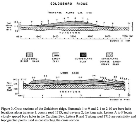
As we can see, there have been may attempts to derive a solution to the enigma of the Carolina bay formation. Our hypothesis takes an entirely different approach, exploring the possibility that the landforms themselves are emplaced terrestrial ejecta, representing the ejecta material of the proposed cometary impacts. This rather unusual solution was initially deduced by the authors after reading the above quotation from the Daniels, Gamble and Wheeler description of the Goldsboro Ridge landform in eastern North Carolina.
The general direction of Carolina bay orientation has been consistently recognized. The Eyton & Parkhurst paper discussing possible cosmic origin, referenced above, includes the following graphic. This was derived from an extensive survey of bays across the Southeast.
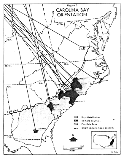
Carolina bay Orientation - Eyton & Parkhurst
Our analysis correlates these structures - including the Goldsboro Ridge - to a cometary impact event that struck the Northerlies American ice shield between at 788,000 years ago. The general "rotation" of inbound ejecta trajectory represented in the Eyton & Parkhurst graphic is the manifestation of two different factors. The first being the the Earth's rotation during the loft period applied to the main body of bays pointing NW. Ejecta droplets traveling on a more southerly bearing will land slightly further westwardly due to the faster west-to-east ground rotation vector. As a result, their azimuth will "seem" to be directed back towards a point further west than the actual ejection point. This effect will reverse if the emplacement site is further towards the pole than the ejection site.
(1) A RE-EVALUATION OF THE EXTRATERRESTRIAL ORIGIN OF THE CAROLINA BAYS by J. Ronald Eyton & Judith I. Parkhurst

Geological Research by Cintos is licensed under a Creative Commons Attribution-NonCommercial-ShareAlike 3.0 Unported License.
Based on a work at Cintos.org.
Permissions beyond the scope of this license may be available at http://cintos.org/about.html.