
Goldsboro Ridge as a Distal Ejecta Structure
The inspiration for our conjecture was an observation in the paper The Goldsboro Ridge, an Enigma, R. B. Daniels, E. E. Gamble, Wheeler, et al.
The Goldsboro ridge is a unique feature on the Sunderland surface and requires special explanation whatever its origin. It must be either an erosional remnant of a once more extensive sediment or a depositional feature....The Goldsboro sand overlies the Sunderland Formation conformably. The contact is always abrupt but there is no evidence of deep channeling, basal coarse material, and evidence of weathering at the contact. Even the Carolina Bays do not disturb the underlying Sunderland materials.... The sand in the bay rim is not different from the Goldsboro sand. Therefore, these Carolina Bays are merely surface features associated with the formation of the ridge.
Here are two graphics from the Daniels, paper. Core and trench sampling here and at other bays explore the characteristics
• Structures stand above local horizons - measured in meters
• Oval shape & orientation consistent across variety of sizes and sites
• Structures within structures, and overlap, while maintaining geometry
• Base contact is always abrupt and easily discernible
• Soil horizons exist continuously under the structure - Bryant (1964)
• The ridge and bay rims are unstratified - singular deposition
• Produced without distorting underlying strata - Preston & Brown (1964)
• Secondary rims can develop; primary always present - Daniels (1977)
Carolina bays are not existent only on flat landscapes. The Goldsboro Ridge Structure includes several clearly delineated Carolina bays within the ridge itself. Here are two graphics from the Daniels, E. E. Gamble, Wheeler paper, The Goldsboro Ridge, an Enigma, as it appears in the on-line archive of Southeastern Geology: Volume 12, No. 3 January 1971.
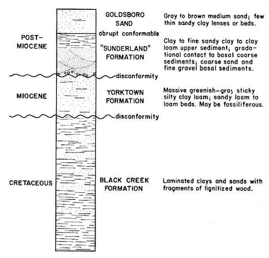
Stratigraphy in the vicinity of the Goldsboro Ridge. - Daniels, Gamble, Wheeler
The reader will note the "abrupt conformable" description provided for the horizon between the Goldsboro Sand and the underlying Sunderland Formation. Our theory suggests that the entire structure know as the Goldsboro ridge is the manifestation of a large mass of ejecta lofted from the Saginaw area. Our experiments have show that Carolina bay -type depressions are often created in the upper layer of such an ejecta emplacement, probably due to the plastic flow of material of different densities and water content as the ejecta droplet spreads across the emplacement site. The next graphic from the Daniels, E. E. Gamble, Wheeler paper presents cross-sectional views of the ridge.
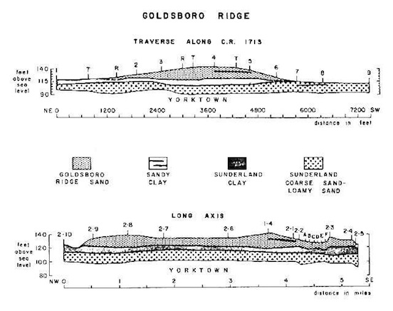
Cross sections of the Goldsboro ridge. Numerals 1 to 9 and 2-1 to 2-10 are bore hole locations along traverse 1, county road 1713, and traverse 2, the long axis. Letters A to F locate closely spaced bore holes in the Carolina Bay. Letters R and T along road 1713 are resistivity and topographic points used in constructing the cross section - Daniels, Gamble, Wheeler
The location can be seen in Google Earth, using the following KMZ file
The test holes at A through F demonstrated that the Carolina bay was, in fact, a feature created along with the rest of the Goldsboro Ridge sand formation.The Goldsboro sand overlies the Sunderland Formation conformably. The contact is always abrupt but there is no evidence of deep channeling, basal coarse material, and evidence of weathering at the contact. Even the Carolina Bays do not disturb the underlying Sunderland materials (Figure 3). The sand in the bay rim is not different from the Goldsboro sand. Therefore, these Carolina Bays are merely surface features associated with the formation of the ridge. The contact between the Goldsboro sand and the Sunderland is easily recognized by the abrupt decrease in clay content and the large increase in silt. The Goldsboro Ridge, an Enigma by R. B. Daniels, E. E. Gamble and W. H. Wheeler
The distal ejecta hypothesis postulates that virtually all ejecta will emplace with the characteristic ovoid/tear-drop/pear shape. The Goldsboro ridge, while certainly a massive structure, does not itself present this shape. The following graphic (linked to higher resolution image) is from the Google Earth GIS system. What is apparent in the image is that the ridge is itself a primary member of a much larger Carolina bay structure. The ridge represents the basic tenant of the emplacement concept: During one simultaneous event, this broad layer of ejecta was catastrophically spread over the landscape, and the Carolina bay were turbulently created in the strata. The keyhole file is available via the KMZ link.
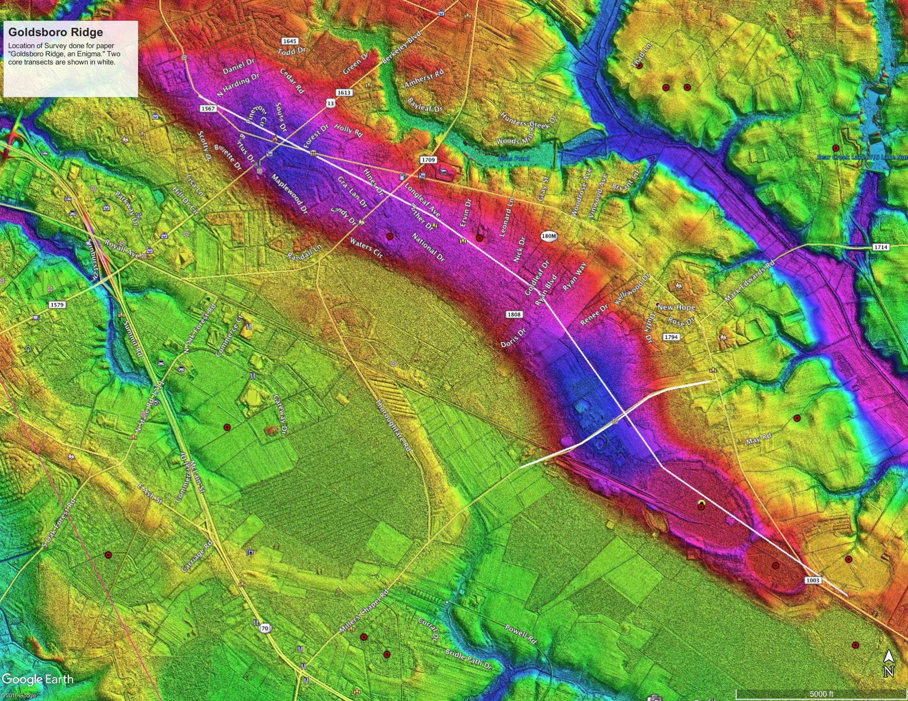
Goldsboro Ridge, NC Here is an image captured from Google Earth using the kmz linked above. A higher resolution version is available by clicking on this image.
In another LiDAR view, 1/9 arc seconds, we see the ridge detail, along with the two bays within the ridge. The graphic includes the Global Mapper elevation profile across the central bay, up the ridge and down through the two ridge bays. The elevations represented are significant. The graphic is linked to a higher resolution version.

As we can see, there have been may attempts to derive a solution to the enigma of the Carolina bay formation. Our hypothesis takes an entirely different approach, exploring the possibility that the landforms themselves are emplaced terrestrial ejecta, representing the ejecta material of the proposed Saginaw impact. This rather unusual solution was initially deduced by the authors after reading the above quotation from the Daniels, Gamble and Wheeler description of the Goldsboro Ridge landform at the top of this page.
In another paper, Daniels and Wheeler discuss the ridge in the context of the entire costal plain:
It must be admitted that a marine origin for the ridge is not proven beyond any doubt, but at the present it seems to be a good working hypothesis. One difficulty is that the only disconformity that can be traced is at the base of the sand ridge where it overlies the fine upper part of the Sunderland. This suggests that at most places on the Sunderland surface near Goldsboro, the transgression resulting in the Goldsboro Ridge did not leave any other evidence behind.