
Saginaw Impact Structure
Our analysis correlates numerous proposed ejecta structures - including the Carolina bays and the Goldsboro Ridge - to a cometary impact event that struck the Mid Pleistocene MIS 20 ice shield approximately 786,000 years ago.
The graphics below presents a view of the glacial coverage of NA at the furthest advance of the Illinoian age, and it is likely the ice sheet at the peak of MIS 20 would have been more extensive.
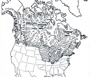
North American Ice Sheet
We have theorized that a shallow angle-of-incidence impact occurred into a 1k to 2km thick ice sheet, which dissipated much of the impact energy. The oblique impact is seen as carving out shallow, oval impact craters, as discussed in the Unique Impacts chapter.
Pulverized ice effectively mobilized and hydrated the ejecta, which would have been composed of sedimentary strata from the terrestrial crater, elements of the impactor and significant quantities of ice from the glacial cover. Invoking an Illinoisan Ice Sheet also provides a vehicle to minimize local ejecta, as it would have landed on the sheet and eventually be carried south and deposited across Michigan, Indiana and Ohio. As a direct result of the impact, sheets of distal ejecta are seen as being propelled at high velocities to fall as a "rain" of debris across the continent. A primary focus of our review of that debris is the enigmatic Carolina bay landforms. These landforms, discussed in the Distal Ejecta chapter, present an ovoid shape that suggest an inferred alignment. While these are often accepted as being wind-driven sand dune and lacustrine landforms, aligned with the prevailing winds, we see them as "paint splatters" spread as a coating by the distal ejecta sheet. Attempts tracing "back along" the inferred alignment has presented a fuzzy focus, where the southern-most bays' alignments seems to rotate further to the North.
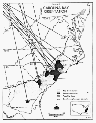
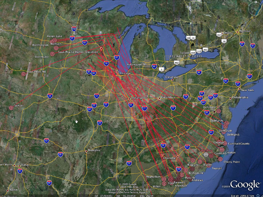
Carolina bay Orientation - Eyton & Parkhurst
The general "rotation" of inbound ejecta trajectory represented in the Eyton & Parkhurst graphic (discussed in the Carolina bays section) is the manifestation of two different factors. The first being the the Earth's rotation during the loft period (systematic by loft time). As a result, their azimuth will "seem" to be directed back towards a point further west than the actual ejection point. This effect will reverse if the emplacement site is further towards the pole than the ejection site. In the second effect, ejecta droplets will be skewed along the w>e axis due to the change in west-to-east ground rotation vector between the latitudes of the ejection site and the landing site, which we refer to as "systematic by latitude". A more detailed discussion of this aspect of the Carolina bays is discussed in the Inferred Alignment chapter.
The Carolina Bays display a marked alignment with northwest-southeast being the preferred orientation. Although there are minor local fluctuations, deviations from the preferred orientation appear to be systematic by latitude (Prouty, 1952).(1)
The following Google Earth graphic represents the first-pass great-circle trajectories in our heuristic evaluation of bay inferred alignments.
Carolina bay Initial Trajectory Set - linked to higher resolution image
The evaluation of the various systematic adjustments to the inferred ejecta trajectory has suggested a rather chaotic set of variations can exist, but that the first order effect is the loft time shift. A mean average of all optimum trajectories was used to generate a proposed single point loci for an impact point. The location at 43.6259 North Latitude and 89.7043 West Longitude was computed. We extended the green line seen in the graphic below east along the indicated latitude to identify possible crater sources, using the surrogate crater conceit. This lead our search to the Saginaw Bay area.
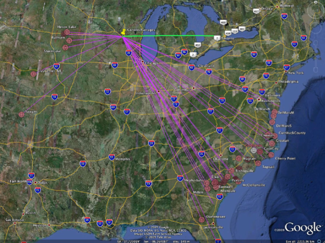
Carolina bay Optimized Average Trajectory
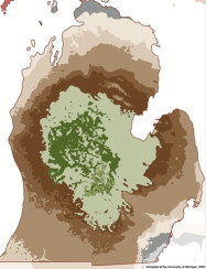
The following graphic Compiled at the University of Michigan describes the bedrock located within the Michigan Basin geological structure. The central zone is composed of later, more solidified carbonate rocks, whereas the younger underlying rocks are softer shales and sandstones built up prior to the origins of life and the calcium deposits derived from shells. The ice age glacial sheets which removed vast quantities of strata from above the basin were unsuccessful in breaching this carbonate layer to any degree with one major exception - Saginaw bay.
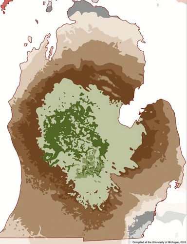
Saginaw Bay Breach of Michigan Basin - Compiled at the University of Michigan, 2003
Heuristically Modeling a Saginaw Bay Cosmic Impact
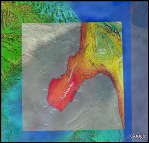
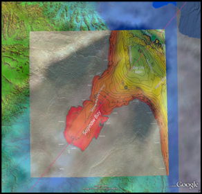
The Google Earth visualization facility was again leveraged to test fit an elliptical geometry into the profile of the Saginaw bay Lobe, attempting to define a arrival bearing for the impacting body. Note the blue drainage basin lines at the southern end of the proposed craters. These represent the drainage flow of the main Kankakee Torrent discharge source. We propose that the "crater" in the ice sheet fills with liquid water and is eventually drained disruptively to the south in an event know as the Kankakee Torrent. Anyone with casual knowledge of that massive torrent event would probably assume it was from the Lake Michigan lobe moraine lake, but it was not - it was sourced out of south-central Michigan, in the area of Union City.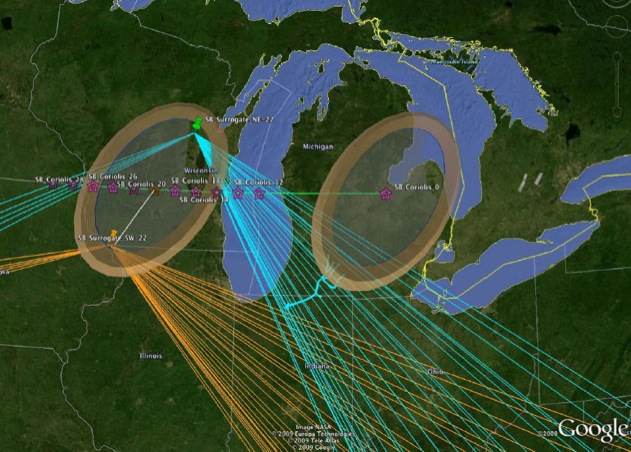
First-Pass Surrogate Crater with Control Bearings & Proposed Saginaw Bay Crater @ 22 Minutes Loft Offset
At the present time we are investigating the existence of any correlated anomalous scientific data about the Saginaw Bay area and the Wisconsin-era Glacial Lobe associated with it. Among the items identified to investigate:
- Anomalous hydraulic pressures in the surrounding strata layers
- Anomalous glacial deposits, with large bolder fields juxtapositioned within similarly dated, but smaller sized debris
- Identification of Precambrian deposits in glacial till, unique to the Saginaw lobe and not seen in any other Wisconsin-era lobe deposits
- Upwelling of Heavy Metals seen in Saginaw Bay Sediment
- Buried sub-glacial runoff channels suggestion the deposition of terrestrial debris on top of glacial sheets
- Anomalous buried soil layers suggesting deposits above warmer climate flora.
- Anomalous salt-bearing springs surrounding the Saginaw bay; used for commercial salt production in 1800s
- Unusually High Helium Atmospheric noble gas signatures in area aquifer fluxes
- Carbon dating of natural gas from wells across Michigan Basin show activation ~13kya
- Research suggests significant basin re-heating event in past; reactivation of Keweenawan Rift implicated by others
Researchers have examined the "moraines" of the Saginaw Glacial Lobe and have offered several solutions to their anomalous relationship with the other Wisconsin-Era Ice Sheet lobes. Both the Michigan and the Huron/Erie lobes are seen as having overridden the original terminal margins of the Saginaw lobe, presenting a confusing picture of its advance and retreat. We ask the question: did the "Saginaw Lobe" ever exist?, or could the excision of the central Michigan landscape be the result of a cosmic impact? While there is good reason to expect that the central Michigan Peninsula was covered by a deep ice sheet, as it traversed down from the North, we question the existence of the "plunge" and focused Saginaw lobe advance from the northeast as commonly portrayed.
Our current proposal holds that the impact carved out much of the current bedrock topography of the Michigan basin surrounding and west of the Saginaw Bay. Local ejecta, distributed in a butterfly pattern, was heaped on top of the then-present ice sheet. As the sheet melted beneath the ejecta blanket, many of the enigmatic "moraines", hummocks and tunnel landforms were created. Eventually, the large lake created within the ice sheet crater catastrophically drained southward, similar to that assumed to have occurred during the post-LGM Kankakee Torrent, and later the Central Kalamazoo River Valley (CKRV). Following the first glaciation, we propose that each of the following 6 to 10 re-advances of the ice sheet over the following 700,000 years effectively beveled and removed most of the impact evidence
Oblique Impact Crater on Mars with ejecta butterfly
We theorize that the impact occurred into a 1k to 2km thick ice sheet, which adsorbed much of the impact energy. Pulverized ice effectively mobilized and hydrated the ejecta, composed of sedimentary strata from the terrestrial crater, ice from the overlying sheet, and elements of the impactor. Much of that volume would be deposited locally, but we note that invoking an Illinoian Ice Sheet at MIS 20 also provides a vehicle to minimize local ejecta, as it would have landed on the sheet and eventually deposited randomly as glacial till over the following 7 glacial eras.
Here is an elevation profile generated in Global mapper using USGS NED data.
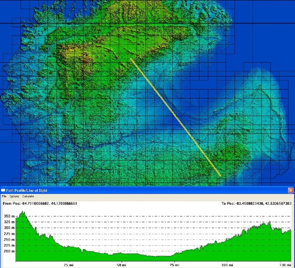
Saginaw area elevation profile

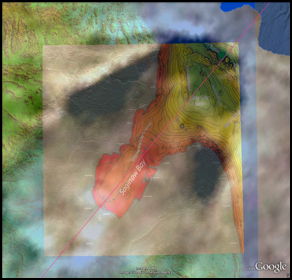
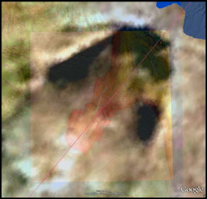
Oval Crater as Google Earth Overlay on Saginaw Region
The graphic below presents a cross-sectional view of the proposed crater. Several layers of terrestrial strata were excavated, along with a substantial layer of glacial ice overburden. Local terrestrial ejecta was emplaced on top of the ice sheet, facilitating later transport and dispersal as glacial till.
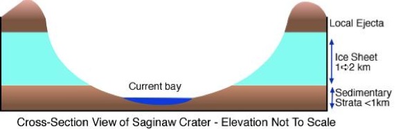
Saginaw Crater Cross-section Comic
Ejecta Volume Calculations
Using the cut/fill facility in Global Mapper, we calculated that the crater excavated approximately 2,300 cubic kilometers of sedimentary strata from the crater. Given a conservative average ice cover of 500 meters, the 32,000 square kilometers of crater surface area would supply another 16,000 cubic kilometers of pulverized ice to the slurry mix. A 30 km impactor would supply ~14,000 cubic kilometers of hydrated silica. These values would yield a sand/water ratio of 1:1. A substantial majority of the 16,000 cubic kilometers of ejecta would likely fall locally back onto the ice sheet, to be distributed as "glacial till" as the sheet retreats. Using a conservative estimate of 10% as distal, the 1,600 cubic km of debris would be capable of blanketing 300,000 square kilometers of North America with a 5-meter thick distal ejecta sheet.
Radial Ejecta Loft Distances
The distribution of Carolina bay formations is geographically distributed radially around the chosen Saginaw centroid, as shown in the following chart. The fields are ordered by their position in a clockwise walk around the locations, beginning in the east.
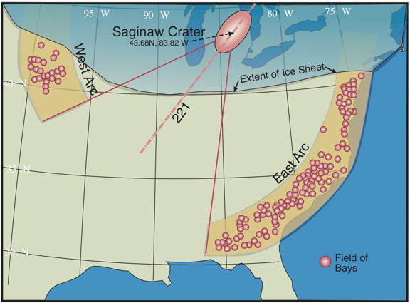
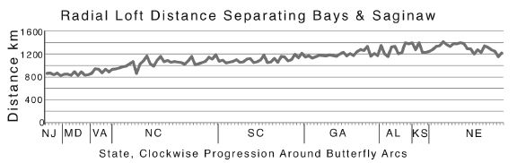
Chart of distance from Saginaw Centroid to ~140 fields of Carolina bays documented to date
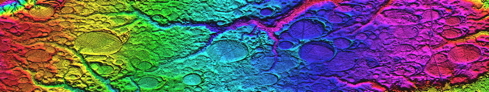
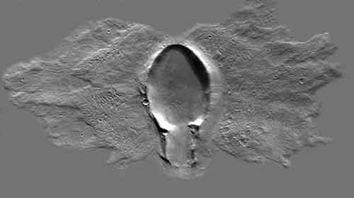
Early in our oblique impact research, we identified an example crater on Mars which presented the oval shape and butterfly distribution of local ejecta. This Martian crater departs from a pure oval shape along some of its rim, and perhaps by pure coincidence, so does the topography of the Saginaw Bay area....in the same areas! Here are 6 images showing the Google Earth view of Saginaw, with an overlay showing a color ramp elevation DEM, along with the Mars crater overlay (adjusted for orientation and size to match), while changing the transparency of the latter.
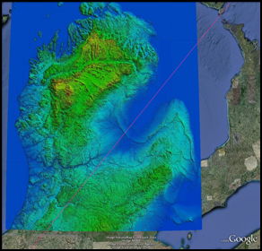
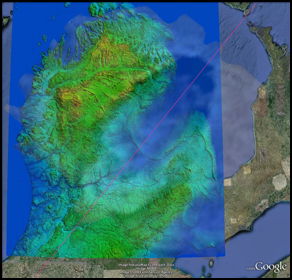
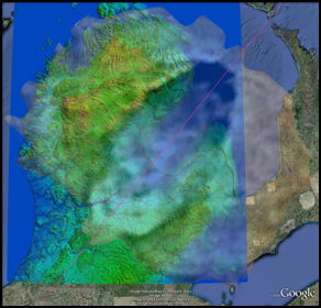
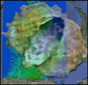
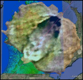
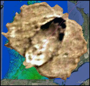
Along with the correlation along the rim, the general land mass of northern lower peninsula seems to bear the traces of the ejecta spray. Lake Huron, of course is excised by the glacial flow known to have passed thought that area. Note how the Mars flow stops "at" the northern Lake Erie shoreline...
Just a coincidence?
Another comparison can be seen in the Lake Huron bathymetry overlay (courtesy NOAA), when compared with the Mars overlay. One characteristic of shallow, oblique impact craters is that the deepest excavation is right at the uprange opening of the crater. Here, that aligns with the Bay City Basin.
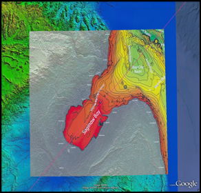

Once excavated into a 2km-thick sheet of ice, we expect the "crater" to have filled with water and eventually drained south-west catastrophically as the Kankakee Torrent and CKRV episodes. Glacial incursions across the crater floor from the Huron Lobe would explain the current glacial moraines along the Bay shoreline seen today.
An embedded Google Earth browser which displays our proposed Saginaw Impact Crater is included in the chapter pages.
The following kmz file includes the three overlays and the azimuth line, so the viewer can open these in Google Earth, and using the Get_Info/Edit > Transparency slider, adjust the overlays to see the correlations shown above.
(1) A RE-EVALUATION OF THE EXTRATERRESTRIAL ORIGIN OF THE CAROLINA BAYS by J. Ronald Eyton & Judith I. Parkhurst