Corelating the Orientation of Carolina bays to a Cosmic Impact
Welcome
Overview
Oblique Impact
Distal Ejecta
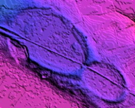
Bay Planforms
Modeling Bay Orientations
Survey
Searching for Bays
Field Survey
100K Quads
Bay Map
Barnwell
Elizabethtown
Florence
Georgetown
Laurinburg
St. George
Sylvania
Walterboro
Wilmington, NC
Survey Calulator
Overlay Generator
SC Survey
Bearing Calculator
Saginaw Impact Structure
Event Timing
Google Earth GIS
References
Georgetown 100k Quadrant Results
This quad has minimal coverage in high quality LiDAR.
The kml image is linked to the bay survey for view in Google Earth:
This chart displays the range of bearings across the hectare size of the bays.