


Survey of Carolina bays by Fields
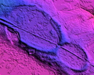
The use of high resolution LiDAR DEM imagery has allowed for the identification of Carolina Bay basins across the country. The digital size of the images has motivated us to create a survey based on “fields” of bays, such that areas which are void of bays are not covered with LiDAR detail. We have created ~250 such fields, which can be reviewed in a Table.
For each field, we have used the Bearing Calculator to generate trajectories, both predicted (by the model) and based on the actual measured bearing for the field.
Access to the datasets for these bays can be done using several interfaces. The table mentioned above contains links to the KMZ file for each field. Graphically, our LiDAR viewer contains links which will retrieve the Lidar on the virtual globe. In addition, the Field Index is available for drill down into each field.
The “Distal Ejecta Field” KMZ file is available to LOAD directly into Google Earth.
A Google Fusion Table is available to review the metrics of the fields. The widget below is generated from this table over the cloud.