


Timeline Discussion
Our exploration of the Saginaw manifold proposes that event occurred approximately 14 kya to 27kya. The event may have been the trigger for the Kankakee Torrent, whose age has not been well established in spite of it's known massive scale. The dating across the globe will vary slightly, as some events may not have had global impacts relevant to the central NA area of this river. There is evidence that a global meltwater pulse 17kya, and again at 14kya. Recent studies confirm that the sea levels around the world rose extremely rapidly (13.5-24 m) during this time. (Fairbanks, 1989 ; Bard et al., 1990 ; Blanchon and Shaw, 1995 ; Hanebuth et al., 2000 ).
Dating of Carolina bays has generate a wide range of results, from mid Holocene all the way to 100kya. Given an ejecta blanket, it is quite possible that OSL dating will not be effective. OSL ant TSL both necessitate a reset event, which may not have been applied to the ejecta as it was distributed. Certainly the multi-hour sun light exposure required by OSL would be impossible to apply to a curtain wall of ejecta in flight for mere minutes.
A pair of possible dating clues have been recently investigated. The Ancient Baldcypress forests found buried in South Carolina are intriguing. The wood being recovered has been tentatively dated at 25kya. David W. Stahle etal, 2005, have published a paper on their findings, and offered the following:
"The recovery of well preserved baldcypress logs from two separate deposits of late Pleistocene age in South Carolina raises many interesting research questions. The most immediate question concerns the genesis of the buried white sand layer and the many large subfossil cypress logs it contains. Does the white sand unit represent a single depositional event or a slow process of accumulation over centuries to millennia of time?"
The discovery of Carolina bay formations in Nebraska (Zanner, 2001) was accompanied by an extensive coring regimen which suggested that the bay topography was overlain by a loess deposit dated to 27kya (Kuzila 1999) , suggesting establishment of the general bay planform prior to the loess deposits. Johnson
A review of the Greenland Ice records show that a two swift changes were seen at the advent of the Bölling-Allerød period. In the first case the change was a rapid warming, coincident with a significant increase in snowfall across Greenland. Can an impact could stimulate warming rather than suppress it as in a "nuclear winter" event? Perhaps.
Our rational is this: Initially, the injection of significant impact energy, both through the atmospheric friction and impact energy release as heated material, could warm the atmosphere. While that alone would likely dissipate in a short period of time (as would a cloud-cover- induced nuclear winter), such an impact would distribute a sheet of ejecta across a significant component of the Wisconsin ice sheet. The resulting change in albedo of the sheet could trigger a warming event that could last for hundreds of years while the sheet melted back (which it did, btw). The water vapor injected into the atmosphere at impact could have been responsible for the snap upward of snow accumulation 15 kya. Our explanation would relegate the YBD to a natural relaxation back to pre-impact conditions, eventually to be overtaken by the general warming trend that began 19 kya due to solar cycles.
The following graphic from the National Academy of Science's pamphlet Abrupt Climate Change: Uinevitable Surprises identifies a sudden change at 15kya.

Climate changes in central Greenland over the last 17,000 years show a large and rapid shift out of the ice age about 15,000 years ago, an irregular cooling into the Younger Dryas event, and an abupt shift out of the event (a warming of about 8° C in a decade) toward modern values.
A Heuristic Argument
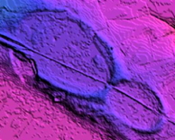
Our analysis correlates numerous proposed distal ejecta material emplacements - including the Carolina bays and the Goldsboro Ridge - to an oblique impact event that struck the Wisconsin-era ice shield. We demonstrate how our analysis of the sequences, orientation and geometry of the proposed crater and distal ejecta support our conjecture. Our methodology for determining the origin of the posited "ejecta" has been heuristic. Alignment were proposed to locations across the US, and a geometric centroid was determined by averaging the first pass triangulation points. Using that centroid, an east-west line was drawn along the latitude of the average, and using our "surrogate crater" conciet, we searched to the east to identify a likely landform to investigate as an impact crater. Our first investigation target was Lake Michigan. When that structure was comfortably maintained as a glacially carved lake basin, we moved further east to the Saginaw Bay area of Michigan.The general Taurid Complex has been resident in the inner solar system for a period of time which covers the Holocene and the several thousands of years preceding. A paper by Steel, Asher, and Clube describes a proposed evolution of the complex of cosmic debris.
A note first on “timing.” A valid question relates to the statistically validity of such a singular catastrophic series of events occurring in our recent historic past, considering the earth’s age at over 4 Billion years. Why now?
We consider the following to be the appropriate response:
The hypothesis suggests that the stabilization of the earth’s climate was driven by the Saginaw Impact Manifold. Perhaps the rapid development of civilization can be considered a direct result. A valid premise would be that had the events occurred 50,000 years ago, civilization would be 35,000 years ahead today. Conversely, had the impact sequence not occurred, mankind would today consist of tribes of hunter-gathers.
Climate has been viewed as a major force in the dramatic changes seen in Human Civilization over the last 10,000 years. Some of the pertinent details are discussed by Dr Benny Peiser in his essay Climate change and civilization collapse.
Figure 1 displays the variations in the temperature of the lower atmosphere over the last 400,000 years. The variability is quite extreme, compared to the stability seen in more the recent past ("global warming" included).
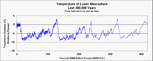
Figure 1- Global Climate over past 400,000 years
A detailed look at the most recent 50,000 years (Figure 2), demonstrates how the temperature has inexplicitly “flat-lined” since 10,000 years ago (BP). Using this chart, we hypothesis that the impact sequences began 17,000 years ago, with a second event at 13,000 BP. We interpret the stabilization at 10,000 BP as being indicative of a massive series of impacts occurring at that point. At regular intervals of ~2300 years, we expect to see additional series of impacts. The last series is fairly well placed from ~480AD until ~1050AD

Figure 2- Global Climate over past 50,000 years
The hypothesis suggest that the startling stabilization of the earth’s climate since 10,000 years ago was driven by significant increase in available water on the planet. The forms are both as greater ocean surface area and the presence of millions of new freshwater bodies. The 50k-year climate chart (Figure 15) provides a clue to when the majority of this geomorphology occurred. We provide Figure 3 only as an initial "straw man" for the sequence series. The greatest influx is expected to be during the recognized transition into the Holocene, when the sea levels rose by 40 meters in as few as 400 years.

Figure 3- Global Climate over past 20,000 years
The Blytt-Sernander classification has been proposed to offer an interdisciplinary standard for climate periods.
The Pleistocene phases and approximate calibrated dates are:
• Older Dryas stadial, 14,000-13600 BP
• Allerød interstadial, 13,600-12,900 BP
• Younger Dryas stadial, 12,900-11,500 BP
The Holocene phases are:
• Boreal, cool, dry, rising temperature, 11,500-8,900 BP
• Atlantic, warm, moist, maximum temperature, 8900-5700 BP
• Subboreal, 5700-2600 BP
• Subatlantic, 2600-0 BP

Figure 4-