

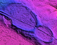


This quad has excellent coverage under LiDAR.
The ~60 identified bays have an average bearing of 137.17 degrees, with a standard deviation of 2.704.
The kml image is linked to the bay survey for view in Google Earth:

Histogram of Bay Sizes in 1 Hectare Buckets

Ratio of Major/Minor Axis length vs Bay Sizes (hectares)

Inferred arrival Bearing (degrees) vs Bay Sizes (hectares)
The Wilmington area gives a good example of how bays have slowly become less apparent on the landscape, yet continue to show well in high-quality LiDAR. Here is a sequence of images to make the point. The first image was taken in