LiDAR Imagery - It’s a Beautiful World
“Carolina
bays“
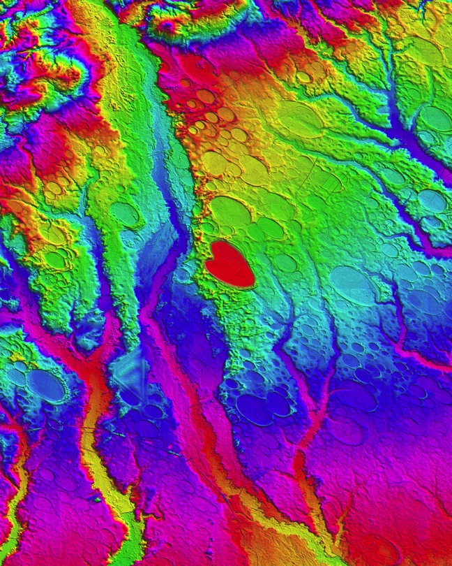
This Digital Elevation Map
covers ~ 600 square km centered on Rex, NC (Robeson
County), and was generated in the Global Mapper GIS program
using LiDAR data from the USGS. The colors shown are an
indication of topographic elevation, from 16 m AMSL in the
lower right, to 76 m in upper left. Vertical resolutions of
centimeters allow for visualization of the form and extent
of the bays’ otherwise imperceptible rims. Rockfish
Creek flows along the northern edge. CSX’s Atlantic
Coast Line rail bisects the area diagonally along a
strikingly straight right-of-way; Interstate 95 winds N-S
on the right. The KML is available for visualization in
Google Earth HERE.

Carolina bays (Image linked to high
resolution version)
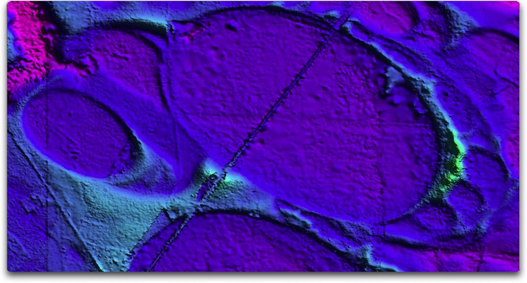
The source TIFF file for the above DEM is 36” x
24” at 300 DPI. As an example of the detail it
contains, the image below is shown at 100%. The area it
elaborates on is just left of the center of the image
above.
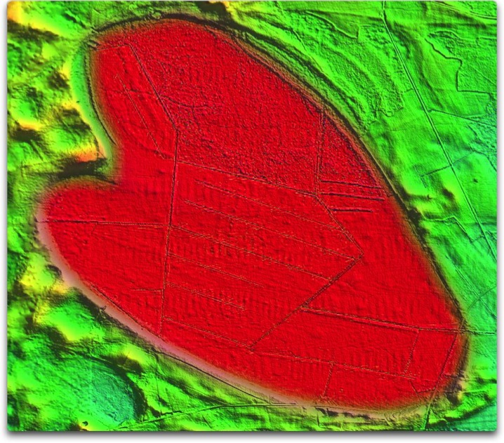
The image below is from immediately west of the image
above. The image was edited to change the hue of the
heart-shaped bay, but not its shape. The KML to visualize
this area in Google Earth is available HERE. A high resolution
version is available HERE.
Heart of the Carolina bays
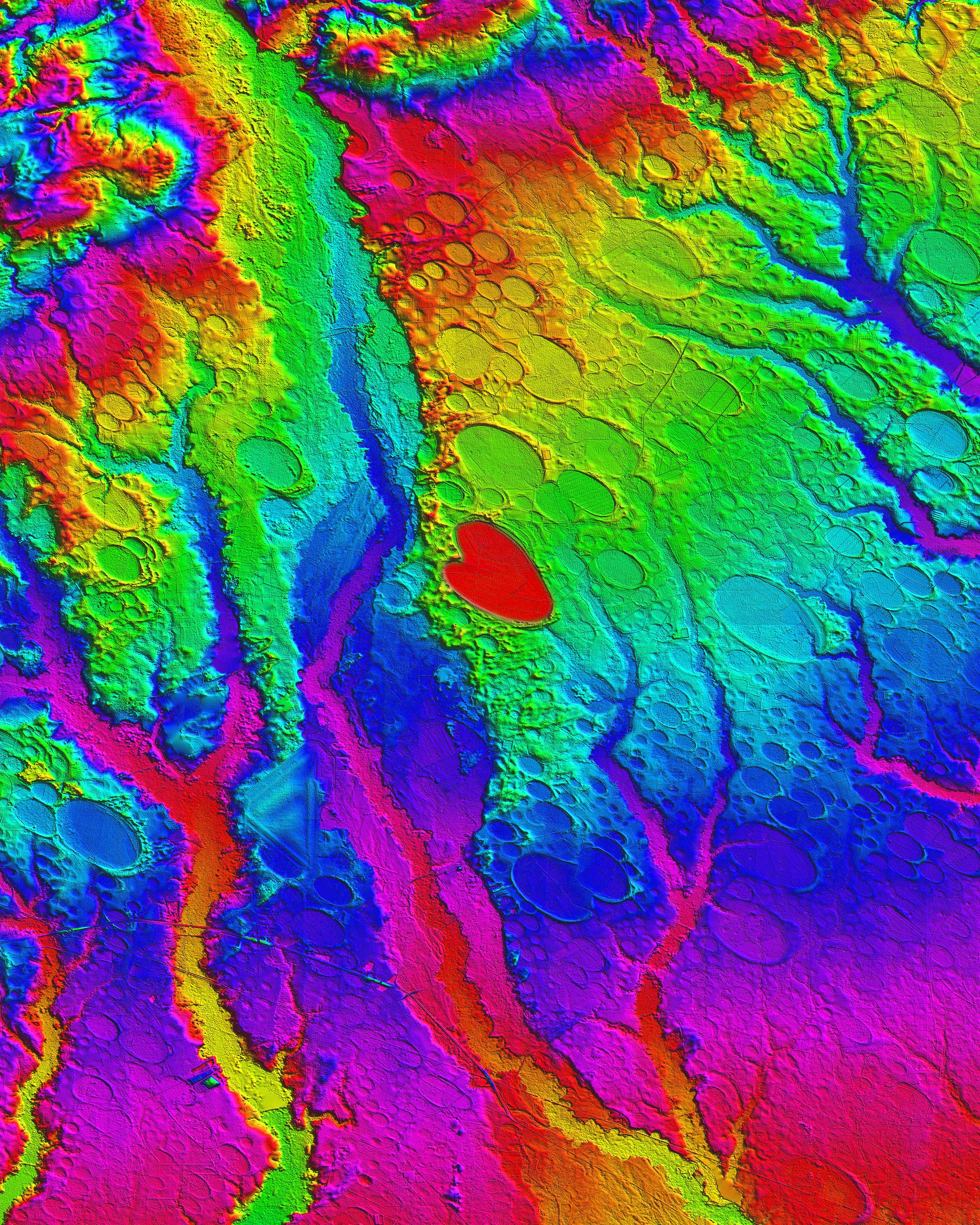
For another view of the heart, here is the
view in the Google Earth Plug-in HERE
Again,
the source DEM map holds significantly more detail than
can be presented here. The image below shows the heart
bay at 100% resolution:
Heart
Detail
This map is from the Fayetteville, NC 100K
quadrant. A 300 dpi 20”x25” high resolution
version (95MB) is available HERE.

Fayetteville, NC
The large bay at the top of the above image is located just
south-east of Benson, NC. The landform is quite complex,
with indications of multiple smaller bays fully embedded
within the larger one. The image below highlights this
area, and a higher resolution version (13MB) is available
HERE.
Benson, NC
The image below is from the Bennettsville, South
Carolina region. A high resolution image (2MB) is available
HERE.

Bennettsville, NC
The image below is from the Quitsna, North
Carolina region. A high resolution image (10MB) is
available HERE. An interesting feature is that
the two bays here seem to exist on top of the ancestral
fluvial fabric.

Quitsna, NC
Another “river bay” image below
is from the Conetoe, North Carolina area. A high resolution
image (10MB) is available HERE. These assortment of bays here
exits mid-stream across a large drainage
basin.

Contoe, NC
Here are bays on a peninsula between the
bays ... image below is from the Currituck, North Carolina
area. A high resolution image (9 MB) is available HERE.

Currituck, NC
Close up images of bays in South Carolina
reflect the higher LiDAR resolution available with new
LiDAR vs the 10-year old data from North Carolina... image
below is from the Benson, South Carolina area. A high
resolution image (3 MB) is available HERE.

Benson, SC
In many areas bordering river valleys, sand
dunes can be seen moving west-to-east across the bays.
Often the bay survives the invasion... image below is from
the Georgetown, South Carolina area. A high resolution
image (13 MB) is available HERE.

Georgetown, SC
One intriguing aspect of the bay formation
mechanism, is that it was elevation agnostic... It seems
unlikely their formation was controlled by either sea level
or water table. The DEM map below is from the Latta, South
Carolina area. A high resolution image (16 MB) is available
HERE.

Latta, SC