Carolina Bay Survey Maps
The Maps originally shown here were interactively driven by a Google Fusion table. With the demise of that resource, they no longer work. We endeavor to update our site with new tools to reach our information through web pages vs Google Earth.
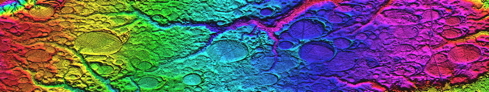
These maps were created using a process discussed in our 2011 USGS National Map Mashathon entry. A detailed slide show of the process is available as a slide show HERE on our cintos.org site, or can be downloaded as an 18 MB PDF flie.

Cintos
A Citizen Scientist at Work