


Glaciation Processes Unique Among all other Wisconsonialn-era Events
We view this paper as providing guidance for understanding the orientation of the proposed Saginaw Bay impact crater over the lower Michigan peninsula. Using the graphic from the paper Riek and Winters paper (bleow), we have aligned the generic oblique impact oval overlay to arrive at a proposed alignment. Among the numerous alignment clues we leveraged are:
- The centerline of the Saginaw bay intrusion into the Michigan basin
- Fitting the lowest elevation of the crater at the up-trajectory end so it coincides with the
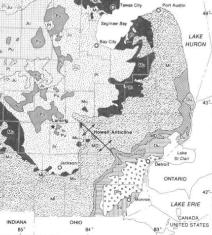

Reference: Characteristics of a Glacially Buried Cuesta in Southeast Michigan
*Department of Geography and Department of Geology, Western Illinois University,
Macomb, IL 61455; and
tDepartment of Geography, Michigan State University, East Lansing, Ml 48824; presently
Visiting Professor, Department of Geography and Computer Science, United States Military Academy, West Point, NY 10996
Abstract.
This study assesses the effects of glaciation on a drift-buried cuesta in southeast Michigan through analysis of detailed data for the underlying bedrock surface. Four separate areas of the cuesta affected differently by glaciation are examined. These illustrate (1) proximal lowering through abrasion, (2) lateral smoothing and trimming, (3) distal plucking and (4) protection resulting from local structural-topographic relationships. It is shown that glacial effects on the cuesta vary in a meaningful way with changes in relationships between bedrock structure, lithology, surface configuration, and the direction of ice movement.
.....
The smooth convex (upward) bedrock surface in Huron County is an especially distinguishing characteristic; no other extensive area of higher bedrock in southeast Michigan is known to have a similar form. Elsewhere in southeast Michigan near the cuesta the bedrock surface is thoroughly dissected by numerous valleys that must have formed largely during a long post-Paleozoic pre- Pleistocene erosional interval. The near absence of bedrock valleys on the cuesta's crest in Huron County, plus their scarcity and shallow nature on the feature's flanks, presents two possibilities: either (1) valleys did not develop on this part of the bedrock surface during the erosional interval that predated the Pleistocene or (2) preglacial bedrock valleys lost their identity because glacial erosion lowered interfluves to levels that, at most places, were at least as low as preexisting valley bottoms.
The first of these two suggestions requires slope development that was distinctly different from that for adjacent areas, a condition that cannot be explained on the basis of known structural characteristics nor the nature of nonglacial gradational processes believed to be active in the area prior to the Pleistocene.
The second interpretation, however, would be expected to produce a deeply abraded but highly smoothed convex erosional surface that is compatible with known geomorphic development of the area; it is also supported by evidence and findings presented in this study.
Furthermore, a minimum estimate of the amount of material removed by glacial erosion may be determined by comparing characteristics of this bedrock surface with valley development in nearby areas less affected by glacial abrasion.
….
The two crests separated by a beveled upland are unlike characteristics associated with either of the glacially modified escarpments in Wisconsin and Ontario described in detail by Martin (1965) and Straw (1968). These forms are also quite different from those on the bedrock surfaces in Huron, Livingston, and Hillsdale Counties, Michigan, described previously. Apparently this part of the cuesta developed in a fashion different from other areas referred to in this study. In these other places Late Wisconsinan ice moved either parallel to the cuesta's trend (Michigan and Wisconsin) or directly toward its scarp (Ontario).
In Branch County, however, the overriding Saginaw lobe moved upward on the feature's dip slope, thence perpendicular to the trend of the prominent crest, and eventually across the cuesta scarp. Such glacial motion over bedrock hills is known to produce a stoss-and-lee topography through abrasion and quarrying. Jahns (1943) has shown that glacial plucking (or quarrying) on the lee side of the preglacial hills in New England (1) was more effective than stoss abrasion and (2) resulted in slope retreat that produced angular cliffed or craggy bluffs. Although, as Flint states (1971 pp. 99-100), the quarrying process may not be fully understood, its effects are clear. The geomorphic development affecting the bedrock surface in Branch County appears to be related to these findings by Jahns (1943).
...
Farther northeast the same cuesta has another form because of glacial abrasion. Ice moving parallel to the feature's trend eroded deeply enough to remove most evidence of preglacial stream valleys, resulting in a remarkably smooth convex surface. And finally, the situation to the south in Branch County is unlike any other area of the Midwest. In fact, nowhere else in North America did Late Wisconsinan glacial movement completely traverse a major structural basin of Paleozoic strata resulting in large-scale "quarrying" of the "down-ice" side of a major cuesta scarp.
...
Figure 2 shows that in Branch County the contact between the Marshall and Coldwater formations lies far to the northeast of the cuesta scarp, yet immediately to the east in the Hillsdale area these two components are adjacent. This curious condition in Branch County, quite unlike other areas described or referred to in this study, cannot be explained by characteristics of bedrock structure or lithology; thus it must be the result of localized but distinct variations in the effect of erosional processes. The same reasoning also applies to the presence of the flat upland developed on weak shale and situated between the two cuesta crests. And finally, geomorphic development (rather than tectonic or lithologic conditions) must also account for both (1) the anomalous presence of the more southerly cuesta crest supported by the relatively weak Coldwater Shale and (2) preservation of the cuesta scarp even though an upper resistant and protective caprock is absent.
...
Leverett and Taylor (1915, p. 154) indicate that in Branch County "blocks as well as small pieces of sandstone abound within the drift." In another report Leverett (1918, p. 54) states that "A morainic area west of Three Rivers ... appears to have been formed mainly by the Saginaw ice lobe, for the Marshall sandstone pebbles abound in its drift, and this sandstone is in the path of the Saginaw Lobe
.. .
" These references clearly indicate that sandstone, much of it angular, is abundant in the drift "down-ice" from the Branch County section of the cuesta. Such lithologic evidence supports our previous interpretation that large amounts of Marshall Sandstone were glacially quarried, a process that must have resulted in significant amounts of scarp crest retreat. Estimates of scarp retreat based on the beveled zone between the two cuesta crests suggest that sandstone caprock was removed from an area of at least 800km2 (300mi2) and involve glacial transport of more than 1.2 x 10⁹m3 (1.6 x 10⁹yds3) of material. On this basis we conclude that large-scale glacial erosion has modified the form and trend of the buried cuesta in Branch County in a distinctive way that directly reflects distribution of susceptible rock and local topography, factors identified by Flint (1971) as especially important in determining the impact of the quarrying process on landform orientation and development.