


Application of Technology
In this section, we will explore the history of using remote sensing to propel the process of moving from hypothesis to proof. In the tab sections listed to the left, we will discuss the various aspects of technology as we apply it to the solution of the Perigee: Zero hypothesis.The Experiments section discusses the rationale and results of experiments performed by us to investigate various physical models. Our use and integration of the geographical information system offered by Google, Google Earth, is discussed.
The Experiences of Several Scientific Pioneers
as related to the application of new technological tools.Copernicus
Nicolaus Copernicus was a Polish astronomer who advanced the heliocentric theory that the earth and other planets revolve around the Sun. This was highly controversial at the time; the Ptolemaic view of the universe, which was the prevailing theory for more than 1000 years, was deeply ingrained in the prevailing philosophy and religion. He formulated the theory in his paper, De revolutionibus , but he died before Galileo's telescope could prove him right.Galileo
Galileo, an Italian astronomer and physicist was the first to use a telescope to study the heavens. His imaging of Jupiter and its satellite moons offered him a unique - and previously unavailable - perspective. This motivated Galileo to become an outspoken supporter of Copernicus's heliocentric theory. In reaction to Galileo, the Church declared it heresy to teach that the Earth moved and imprisoned him. The Church clung to this position for 350 years until Galileo was formally exonerated in 1992.Wegener
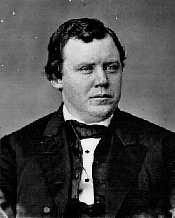
Alfred Lothar Wegener formulated the theory for Continental Drift, but he died before the theory gained prominence. The belief that continents have not always been fixed in their present positions was suspected long before the 20th century; being suggested as early as 1596 by the Dutch map maker Abraham Ortelius in his work Thesaurus Geographicus. However, it was not until 1912 that Wegener published his theory that the idea of moving continents was seriously considered as a full-blown scientific theory. Some scientists have justified the earlier rejection of Mr. Wegner's work on the grounds that he had the continents spreading at a rate higher than they actually are!Harry Hammond Hess
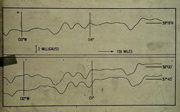
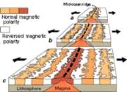
Harry Hammond Hess reformulated the theory around sea floor spreading. But once again, the key was found by the use of a new technological tool: the remote marine magnetometer imaging equipment on the research vessel Pioneer. The theory was supported by Vine-Drummond-Matthews explanation (1) of the magnetic striping seen on the seafloor by Pioneer. In 1966 the Jaramillo Event - during which the earth’s magnetic field completely reversed - was identified, helping seal the discussion.“This discovery, together with data from a 1964 research vessel, transformed the field of geology. It confirmed sea-floor spreading as hypothesized by Hess, and thus "continental drift," originally proposed by Alfred Wegener back in 1912. It convinced many that plate tectonics was the best theory to unify nearly all the previously accumulated, but disjoint geological data.” (2)
Ignatius Donnelly
Ignatius Donnelly previously presented a theory that the earth has been overspread with cometary ejecta. His book, Ragnarok, The Age of Fire and Gravel , provides an excellent review of the unconsolidated, unstratified anomalous landforms he called “The Drift”. His work was slightly flawed by his expectation that only a single comet provided the earth's till, and that earlier cometary impacts were responsible for major geological features that are know today to be Tectonic in nature. Further, he expected that the “Till” is primarily composed of cometary material, whereas the PZ theory suggests that it is primarily terrestrial ejecta in nature.Like Nicolaus Copernicus and Alfred Lothar Wegener before him, he died before adequate technology was available to validate the theory - in this case satellite images and DEM data. Should the PZ hypothesis be proven, no doubt those who have disparaged Mr. Donnelly will point to the errors seen in his work rather than acknowledging that other scientists should have extended his work long before the dawn of the 21th century.
Immanuel Velikovsky
Velikovsky crafted an extensive study of our cultural history and identified an expansive range of events suggesting that the earth was visited by catastrophic events from the heavens. His hypothesis differs from ours in the nature of the cosmic bodies involved. In his book Worlds in Collision, Velikovsky proposed that the current planets Venus and Mars had catastrophic interactions with the Earth during the historical past. Perigee: Zero recognizes the relative permanence of the current planetary orbits and instead suggests that Taurid Complex objects interacted with the earth.We suggest that the names given to the current planets were originally applied to earth-orbiting Perigee: Zero bodies and only later, after their demise during de-orbiting events, were the names transferred to far more remote - and observationally small - sun-orbiting objects. Velikovsky's extensive research into the history of mankind's interaction with cosmic-driven catastrophic events is considered very relevant to the Perigee: Zero hypothesis.
Has science and research matured to the point where such paradigm shifts are no longer possible, given to massive amount of knowledge known today? In the August 2003 issue of Physics Today, Spencer Weart discussed the topic of The Discovery of Rapid Climate Change. He makes a case for why the sudden shifts in climate - now documented - were overlooked for so long. Researchers had no expectation, so they did not look at the data in a granularity that would show the behavior. Instead, a gradual evolution is seen, where researchers expected that significant change required eons but found millennia change, and when they looked for the millennia details they found changes within centuries. Only after looking for century-resolution data did they recognize significant climate changes could occur in timeframes as short as a decade.
Perigee: Zero Technology Use
We have applied satellite photography available from Goggle and TerraServer on the Internet, and the Digital Elevation Mapping (DEM) and LiDAR facilities of the Earth Explorerand Earth mapper programs available as a desktop-based program, to research the findings presented here. As the preparation of this paper proceeds, we will be properly addressing the intellectual property rights issues involved with these images. For the present, we are extending the academic fair use concept, as there is no monetary value being derived from this essay.
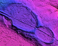
The availability of this enormous detailed photographic database has been crucial to the development of the hypothesis. The visualization of PZ ejecta landform shapes is often arrived at through the subtle shading and textures seen in these photographs, as the ejecta is often no more that a relatively thin veneer across the landscape. The historical representation of landform shapes as presented on maps often does not accurately present the crisp geometric shapes actually existent in the land. Corroborating data in the form of scratches and other manifestations of damage are again only visualized from photographs or other remote sensing imagery.
Coriolis Force
Our interpretation of ejecta arrival azimuths allows the direction from which the ejecta were launched to be determined with a high level of confidence. When conditions exist that the ejecta arrived at an azimuth of 90º or 270º - that is due east or due west on the equator – then the Coriolis force does not affect the calculation. We have used an assumed ejection angle of 30º and an ejection velocity of 4,000 km/hour to arrive at a flight time. The flight time is then used to determine an appropriate eastward or westward displacement relative to a great-circle route ground track.“The Earth's eastward rotation affects ballistic ejecta in two ways: (3) the eastward velocity component increases the velocity of eastbound ejecta and reduces the velocity of westbound ejecta; and (2) the Earth turns underneath inflight ejecta, so that although the latitude of reimpact is not changed, the longitude is displaced westward, with the displacement increasing as a function of the time the ejecta remains aloft.”1
At the time of ejecta emplacement on the earth’s surface, there will be a component of velocity associated with the Coriolis force. As such, the ejecta mass will not spread as symmetrically as expected, since the ground will be moving, in effect, under the mass as it lands. This vector manifests itself as a very slight flattening of one side of the ejecta landform, and an elongation of the opposite side, relative to a geometrically symmetrical ovoid.
1) Discussion of Hess-Vine-Mathews at Hofstra.edu
2) Magnetic bands provide evidence of sea-floor spreading, PBS.org
3)Trajectories of ballistic impact ejecta on a rotating Earth
Authors: Alvarez, W.,California Univ., Berkeley. In Houston Univ., New Developments Regarding the KT Event and Other Catastrophes in Earth History p 2-3 (SEE N94-28294 07-46) Publication Date:00/1994