


The Sand Hills of Nebraska
The Sand Hills of Nebraska represent the greatest accumulation of eolian sand in North America. At the present time, we are researching the extensive body of scientific work available on these landforms to identify any possible correlation to the Saginaw impact conjecture. What is very apparent is the fact that the midwestern loess deposits are anonymously high. Of all the evaluated horizions in the first referenced study, the dating of the "sand" zone the very bottom of the column, preceeding the 32kya Golman Canyon 1 paleosol, would be most likely candidated for evaluation as our ejecta blanket. As we have typically seen, the underlying sand depositions from our ~40 ka event are not considered as relevant, and are not evaluated. Similarly, the Buzzard Roos stuudy, below, identifies a basal stratum at ~40 ky.
The results of work by a USGS tearm (Muhs, Walter, 1994) suggest that U-Pb ages of zircons in the Nebraska Sand Hills support sources that are Precambrian crystalline rocks of the Colorado and Wyoming provinces,. Since both of these are to the west of the Sand Hills, the Hills are likely not ejecta from the late Devonian through Mesozoic sedimentary strata of the Michigan Basin. We do note that there may have been Pre-Cambrian-era sources for sandstones in the target strata.
The overall extent of the Sand Hills correlates very well to our ejecta shape, and aligns precisely with the expected azimuth from a Saginaw Bay impact site. Below is a graphic from Google Earth that includes our kml elements, along with a map (in overlay form here) by Steven Dutch, Natural and Applied Sciences, University of Wisconsin Green Bay. The red great circle lines trending north east come to a focus at the first-pass average locii for the Saginaw Bay surrogate crater.

While the overall Sand Hills "emplacement" takes on an ejecta shape, the deposits are decidedly not Carolina-bay landforms. Our conjecture suggest that not all of the hydrated Michigan strata ejecta would be visualized as bays. Bays would only exist today when the slurry was spread over very flat landscape, and one that received adequate precipitation to keep the bays relatively full of water and therefore stabilized. On rough terrain we see the ejecta blanket quickly sloughing off, and in dry regions, the blanket would be eventually driven into dunes. Carolina bay landforms have been indentified in other areas of Nebraska, but none within the range of the Sand Hills.
A similar suggestion was put forth in 1994 by Evan Hansen, as discussed in Science Frontiers ONLINE No. 93: May-Jun 1994. He suggest that the hills were "deposited by a wall of water sweeping down across the continent from the north -- very likely the consequence of an impact of a large asteroid".
Excerpts below from paper:
Origin and paleoclimatic significance of late Quaternary loess in Nebraska: Evidence from stratigraphy, chronology, sedimentology, and geochemistry
Daniel R. Muhs† U.S. Geological Survey, MS 980, Box 25046, Federal Center, Denver, Colorado 80225, USA
E. Arthur Bettis III Department of Geoscience, University of Iowa, Iowa City, Iowa 52242, USA
John N. Aleinikoff U.S. Geological Survey, MS 963, Box 25046, Federal Center, Denver, Colorado 80225, USA
John P. McGeehin U.S. Geological Survey, MS 926A, National Center, Reston, Virginia 20192, USA
Jossh Beann Gary Skipp U.S. Geological Survey, MS 980, Box 25046, Federal Center, Denver, Colorado 80225 USA
Brian D. Marshall U.S. Geological Survey, MS 963, Box 25046, Federal Center, Denver, Colorado 80225 USA
Helen M. Roberts Institute of Geography and Earth Sciences, University of Wales, Aberystwyth, Wales SY23 3DB, UK
William C. Johnson Department of Geography, University of Kansas, Lawrence, Kansas 66045, USA
Rachel Benton U.S. National Park Service, Badlands National Park, 25216 Ben Reifel Road, P.O. Box 6, Interior, South Dakota 57750, USA
Loess is extensive in the Midcontinent of North America, and Peoria Loess, of last glacial age, reaches its maximum known thickness in the state of Nebraska (Fig. 1). Despite the importance of Peoria Loess as a surficial deposit and soil parent material in this region, little is known of its provenance,
Although the origin of Peoria Loess in the Great Plains of Nebraska, Kansas, and Colorado has been studied for more than six decades, at present there is no consensus on its genesis. As mentioned above, Peoria Loess in the Great Plains has no clear link to outwash of the Laurentide ice sheet, except possibly in that part of Nebraska adjacent to the Missouri River. Previous workers proposed a variety of sources for loess in the Great Plains, including Platte River alluvium (including glacial outwash from the Rocky Mountains); glacial outwash from the Missouri River; sediments from the Tertiary Ogallala, Arikaree, and White River Groups; and sediment from the Nebraska Sand Hills or other dune fields (Lugn, 1939, 1968; Bryan, 1945; Condra et al., 1947; Swineford and Frye, 1951; Reed, 1968; Wright, 1970; Flint, 1971; Smalley, 1995; Winspear and Pye, 1995; Aleinikoff et al., 1999; Muhs et al., 1999).
More recently, Mason (2001) presented two new hypotheses concerning the origin of Peoria Loess in Nebraska. He infers westerly or northwesterly paleowinds, based on his new compilation of loess thickness data. Using preliminary isotopic data presented by Aleinikoff et al. (1998), both of Mason’s (2001) models also assume that an important initial, or original, source material for the Peoria Loess in Nebraska is siltstone of the White River Group, which crops out to the north, northwest, and west of the Nebraska Sand Hills (Fig. 2).
OSL ages reported by Roberts et al. (2003) are consistent with both new and previously reported radiocarbon ages for the time of initial Peoria Loess deposition. In western Nebraska,
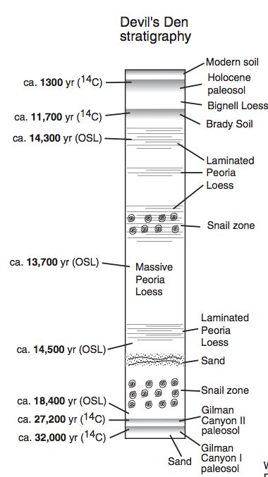
Roberts et al. (2003) report that the earliest Peoria Loess deposition was in progress by ca. 25,000 cal yr B.P. at Bignell Hill, ca. 20,700 cal yr B.P. at Eustis, and ca. 18,400 cal yr B.P. at Devil’s Den (Figs. 3, 4, 7). All these ages postdate the youngest radiocarbon ages of the underlying Gilman Canyon Formation paleosols at each locality. OSL ages at Eustis (Roberts et al., 2003) agree reasonably well with new OSL data for this section reported by Rousseau et al. (2007).
Peoria Loess deposition ended sometime between ca. 14,000 and 12,000 cal yr B.P., based on the uppermost Peoria Loess OSL ages reported by Roberts et al. (2003) and radiocarbon ages of the Brady Soil at Bignell Hill, Devil’s Den, and Moran Canyon.
Because loess in Nebraska is found both north and south of the Platte River system, a question that has arisen is whether the two loess bodies are compositionally distinct (Winspear and Pye, 1995; Muhs et al., 1999). We analyzed two suites of Peoria Loess samples, on both sides of the river system. Major element plots, both (SiO2)/10–(CaO + MgO)–(Na2O + K2O) and (Al2O3 + Fe2O3)/2–(CaO + MgO)–(Na2O + K2O), are in agreement with Winspear and Pye (1995) that loess bodies north and south of the Platte River system are compositionally similar. Trace element plots for Ba/10-Rb-Sr (feldspars and micas) and Zr/10-Y-Nb (heavy minerals) also show that the two loess bodies are not significantly different. Peoria Loess from eastern Colorado, taken from a newly sampled 5-m-thick section near Fort Morgan.
...
Nevertheless, Flint (1971) questioned whether sufficient sediment could have been supplied via the Platte River system to explain the thick loess in Nebraska. Indeed, if the South Platte and Platte Rivers carried glaciogenic silt from the Rocky Mountains to Nebraska, thicker loess should have been deposited in Colorado, but this is not the case (Muhs et al., 1999). Furthermore, for Nebraska one might expect compositional differences between loess on the north and south sides of the Platte River system, unless opposing winds of approximately equal strength and duration had occurred throughout the last glacial period.
We do not consider the Platte River to have been a major source, because loess is compositionally identical on both sides of the Platte River system in Nebraska. Winspear and Pye (1995) also recognized the similar composition of loess on the north and south sides of the Platte River system in Nebraska. They hypothesized that this similarity could be explained by an ancestral Platte River of the last glacial period. In their model, this river flowed north of the loess that is presently north of the Platte River system. However, mapping by Swinehart et al. (1994a) shows that terrace deposits border the modern courses of the South Platte and Platte Rivers in Nebraska for >600 km, and some of these terraces are mantled with loess. Although the terrace deposits are not directly dated, basal radiocarbon ages of fan deposits that overlie the terrace deposits range from ca. 11,000 to ca. 12,400 cal yr B.P. (Faulkner, 2002). These data indicate that the Platte River system was situated at or near its present location for at least the past ~11,000 cal yr and probably longer. Thus, it seems unlikely that the Platte River system had a significantly different course during the last glacial period. Locally, the Platte River system probably contributed some sediment to the loess bodies, a conclusion also reached by Mason (2001) and Aleinikoff et al. (2008), and inferred from the spatial variability in loess particle size presented herein. We conclude from all these considerations that loess in Nebraska, both north and south of the Platte River system, had a common source or sources that lay upwind of both loess bodies.
...
Previous climate-dust models did not simulate significant dust generation in the northern Great Plains during the last glacial period. However, a refined model presented by Mahowald et al. (2006) does simulate a significant northern Great Plains dust source, in agreement with our results. A mesoscale paleoclimate model for North America presented by Bromwich et al. (2005) suggests that Peoria Loess in Nebraska may have been deposited by westerly winds as low-pressure systems passed south of the Lau- rentide ice sheet during relatively dry spring seasons. Our results are consistent with this model, and satellite observations suggest that the process may occur even today.
Stratigraphy and environmental reconstruction at the middle Wisconsinan Gilman Canyon formation type locality, Buzzard's Roost
William C. Johnson , Karen L. Willey , Joseph A. Mason , David W. May, Available online 23 March 2007
Abstract
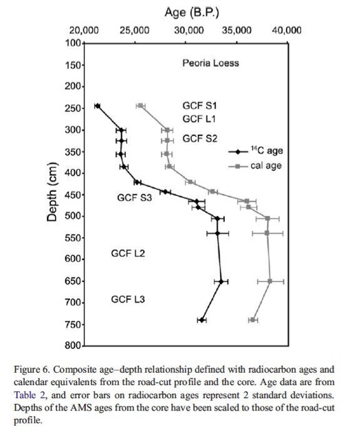
The middle Wisconsinan Gilman Canyon Formation at the Buzzard's Roost type locality in southwestern Nebraska was investigated to document the stratigraphy and to reconstruct the environmental and climate record. The Gilman Canyon Formation was subdivided into three loess units and three soils, with radiocarbon ages constraining it between about 40 ka and 25 ka. Stable carbon isotope ratios, magnetic susceptibility, and carbon content were used to define and characterize soils within both the Gilman Canyon Formation and underlying Illinoian Loveland Loess. At the height of soil development within the Gilman Canyon Formation, climate was supporting C4-dominated grassland, with July temperatures equal to or exceeding those of today. Soil-forming intervals within the Loveland Loess, including the Sangamon Soil, also exhibited relative increases in C4 biomass. Climate, as recorded in the Gilman Canyon Formation, is corroborated by regional proxy data. The formation accumulated during MIS 3, and concurrent soil formation coincided with a summer insolation maximum.
© 2007 University of Washington. All rights reserved.
From this paper, we intrepret the Gilman canyon Formations two lower-most identified strata, L3 and L2, as occupying the position of our ~40 ka ejecta deposit. The following graphic from the paper identifies researcher's age estimations:
Another interesting discussion on the Sand Hills explores the south western extent, where the dunes are seen as having over-ridden an extablished drainage system, causing damming and new drainage patterns. According to the paper, the earliest blockage event was ~ 12kya.
Dune-dammed paleovalleys of the Nebraska Sand Hills: Intrinsic versus climatic controls on the accumulation of lake and marsh sediments
David B. Loope 1, James B. Swinehart 2 and Jon P. Mason 1
1 Department of Geology, University of Nebraska, Lincoln, Nebraska 68588
2 Conservation and Survey Division, Institute of Agriculture and Natural Resources, University of Nebraska, Lincoln, Nebraska 68588
Abstract:
Although running water is the dominant geomorphic agent on Earth, eolian processes can gain ascendancy in regions where the climate is arid, vegetation is sparse, and abundant sand is available for transport. With climate change, the boundaries between fluvial-dominated and eolian-dominated areas may shift. Although there have been few reports in the North American literature of river systems blocked by dune sand, our work in the Nebraska Sand Hills provides evidence of multiple episodes of such blockage events. During prolonged arid intervals in latest Pleistocene and middle Holocene time, eolian dune sand blocked two large valley systems in western Nebraska. These blockages raised the water table of the High Plains aquifer as much as 25 m over an area of 7000 km2 and created over one thousand lakes. Wetlands far removed from the discharge points of the buried paleovalley system are strongly alkaline (exceeding 250 000 mg/L total dissolved solids [TDS]). Relatively fresh (280 mg/L TDS), flow-through lakes are present at the distal end of the system where the gradient of the water table is steep and the cross section of the buried valley is large. Anomalously thick marsh and lake sediments accumulated in deep paleovalleys upstream of dune dams near the southern margin of the Sand Hills. Our cores and radiocarbon dates from Blue and Crescent Lakes reveal their histories to be quite distinct from adjacent Swan Lake; these differences are best explained by multiple blockage events. Our work explains why lakes are most abundant in the driest part of the Sand Hills. It also provides another line of evidence for major dune activity in the Sand Hills region during Holocene time and shows that factors other than regional climate, specifically location, height, and hydraulic conductivity of dune dams, can control the rise and fall of the ground-water table and the chemistry of lakes.
Resolving the Enigma of Late Quaternary Loess on the Great Plains
The following text is from a research proposal by Joe Mason – Department of Geography, University of Wisconsin-Madison
Loess is essentially an accumulation of atmospheric dust, and thick loess deposits provide a long-term terrestrial record of dust transport and deposition. This record is of growing importance in research on past, present, and future environmental change. It is clear that climatic change can lead to dramatic increases in dust production, but recent research also suggests that the resulting high levels of dust in the atmosphere may then have significant feedbacks on climate.
Loess in the central Great Plains records episodes of extraordinarily rapid dust deposition over the past 25,000 years, at rates more than an order of magnitude greater than those recorded during the same time period on the Loess Plateau of north China. These high rates of Great Plains loess accumulation challenge current understanding of major natural dust sources and their past activity. The deserts northwest of the Chinese Loess Plateau are much more extensive than potential source areas for Great Plains loess, and produce much more dust under modern conditions. Numerical models, which successfully reproduce the broad global pattern of modern and last-glacial dust sources, indicate little potential for high rates of dust production in the central Plains, under either glacial or modern climates.
This project will test two hypotheses that, together or separately, may help resolve the enigma of extraordinarily rapid late Quaternary loess deposition on the Great Plains:
Episodes of rapid loess deposition occurred during construction of the Nebraska Sand Hills and other large dune fields from fluvial, eolian, and lacustrine deposits that accumulated in the central Plains since the Pliocene. Rapid eolian reworking of this large store of sediment produced “clean” dune sands and copious dust that traveled farther downwind.Dust produced in the central Great Plains was dominated by coarse, rapidly settling grains, to a much greater degree than dust in other loess systems. This resulted in very high near-source deposition rates, which decreased quickly with distance downwind. An unusually stable boundary between loess sources and sinks preserved thick loess at near-source sites.Both hypotheses emphasize the influence of local geomorphic setting and antecedent conditions on the Great Plains loess system. These factors can explain the gap between the loess record and numerical models of global dust flux, and are also emphasized by recent work on major natural dust sources in the modern world.
Hypothesis 1 will be tested by stratigraphic and geochronologic work to establish the timing of dune field construction. Geochemical and mineralogical data will be used to test whether both dune sand and loess could have been derived from potential source sediments that were present across the region prior to dune field construction, and are preserved as remnants beneath the dunes today.
Hypothesis 2 will be tested by comparing downwind gradients of loess deposition rate (inferred from present thickness) and content of coarse, rapidly settling grains, in the central Great Plains and in the well-known loess of north China.