

Carolina Bays as Distal Ejecta
The Ejecta Depositional Conjecture holds that a sheet of ejecta debris - a slurry of water and sand/silica - was deposited across an arc down range of the Saginaw impact. The sheet exhibits a surface texture of "splatter" marks, which have evolved into today's Carolina bays. The sheet of material is proposed to be quite "thin"; only a few meters of ridge around our splatter mark will hold water. We emphasize that our conjecture does NOT suggest that the bays are either primary or secondary impact structures, but rather exist within a blanket of ejecta material. … Well, at least that is one of many working hypothesis as to how the basins were formed in the ejecta sheet.
We speculate that glacial ice, excised sedimentary strata beneath it in Michigan, and the impactor, would effectively shatter into small particles and intermix in the ejecta curtain wall. The hypothesis holds that from this event a 1-10 meter-thick layer of distal ejecta was spread across the continent. At a certain distance from the crater - seen empirically as 850km to 1300 km - constituents of fine to medium sand was willowing out of the ejecta curtain wall. It was hot, and very hydrous. Effectively we see this as being a frothy mixture that created the bays as bubbles of gas deflated during deposition. The visualization of bays, both in size and juxtaposition clearly represents a physical fractal distribution.
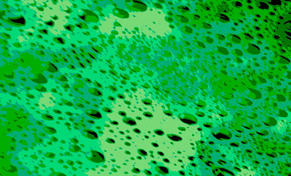
Experimental Results using soap foam and graphical editing
While the majority of inquiries into the bays have been accomplished by probing their interiors, the hypothesis suggests that they are but voids within the ejecta sheet, and the real action is actually between the bays. Many Carolina bays possess classic lacustrine sediment stratigraphy and enclosing shoreline sediments, which is fully appropriate for a basin existing for tens of thousands of years in areas of high water tables.
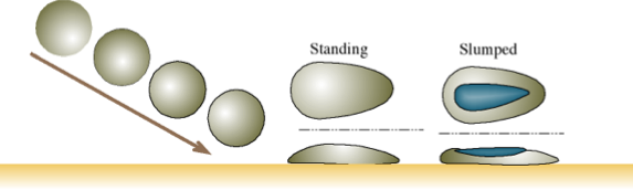
Using the Carolina bays and the Goldsboro Ridge as examples, we propose set of physical characteristics for the manifestation of these ejecta landforms. The characteristics are tightly constrained by the formative processes and circumstances, resulting in a simple, well-defined and unique set of identification criteria to describe these formations. The stylistic geometry and anomalous, unstratified, and homogeneous nature of these landforms are presented as being most indicative of set membership. The typical ejecta landforms are visualized as a pear-shaped, oval or elliptical landform, which sets above the surrounding landscape as a lake rim, ridge, knoll, hill, or island. The figure below demonstrates the emplacement dynamics. The graphic is hyper-linked to a flash demonstration.
Flash Demonstration of Ejecta Emplacement
A series of experiments were conducted to demonstrate the physical process. The results are presented in the Experiments section. Impacting ejecta was modeled by propelling balls of plaster of differing consistency. When they impacted at shallow angles, the balls were spread as bay-shaped forms. More significantly, areas similar in shape to Carolina bays were formed within the surface of the test object. The example presented here was painted to highlight the "bay" areas (in blue).
Quite often the central area of the ejecta slumps upon emplacement, and this slump is manifested as a body of water as it fills over time. We also present these pear-shaped structures existent underwater using various underwater imaging techniques. The scale of observed landforms range from ephemeral pools of a few meters on the major axis, to massive structures such as the Goldsboro Ridge Complex. Our research has shown that the emplacements slam onto the earth and typically remain at that location.
The two major parameters that affect the visualized shape of specific ejecta landforms are the angle of incidence and the hydration ratio. Shallower arrival angles will yield a higher length to width ratio, and wetter material will slump to a greater degree that stiffer, dryer ejecta material. The underlying terrestrial landscape will influence the visualized ejecta shape, such that the stylized shape would be “broken” over terrain that was much rougher than the emplaced material thickness, or too steep to retain the ejecta intact. Nevertheless, we strongly suggest that the resulting ejecta landforms are seen to retain the suggested geometry across the entire range of landform sizes, thereby facilitating the recognition of the ejecta using remote imaging techniques.
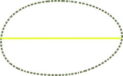
The standardized template used to identify and validate a proposed structure is shown below. The outline is used by us in the Google Earth facility as an overlay to discriminate ejecta deposits.
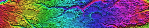
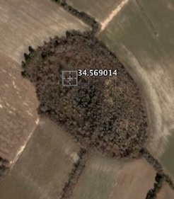
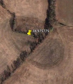
The geomorphic signatures seen in these structures are many, and no other deposition method has been implicated satisfactorily. Arriving from the upper left in the image below, the sheet of debris slammed into the terrain, and spread across areas of varying elevation. Within a few hundreds of meters, we see Carolina bays created at significantly different elevations, as well as having them overlaid and/or partially obscured by additional material arriving moments later. All "Carolina bay" fields we have been able to identify are positively for correlated to a cosmic impact as causal source.
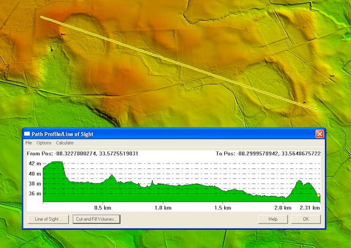
Co-located Bays seen at significantly different elevations
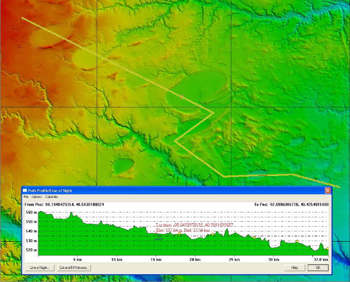
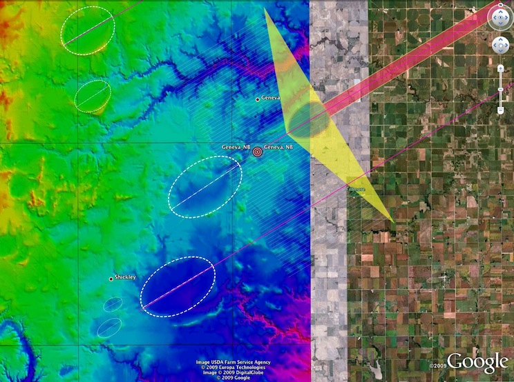
The situation is similar out to the west. The Clay Center, Nebraska area has a significant emplacement of "Carolina bay" ejecta structures. In this case, the elevation differences are even more striking. In the graphic below, we see bays of similar alignment spanning an elevation difference of 40 meters in the range of 30 km. Obviously these are not likely former oxbows in a lazy river.
An extensive display of the "fields" we have investigated in Google Earth is available on the “Bay of the Day” page. Links to kml files for use in Google Earth is available there, also.
With an incoming velocity of close to 1,000 km/hour, the slurry surged forward at impact and created slightly higher rims on the SE end of the splash bay. The ground speed difference effect driven by the latitude delta between the Michigan ejection point and the deposition location would have subtracted from any west-to-east velocity component. The result would be expected to distort the surficial bay features along the E-W axis, which has been reported:
: (1)"Many bays, however, lack true bilateral symmetry along either the major or minor axis. ….the northeast side bulges slightly more than the southwest side.
Along with the compression, we believe the inferred orientation of the bay becomes skewed from its expected arrival direction. This effect is referred to by us as "systematic by latitude", as the effect is a function of the latitudes involved.
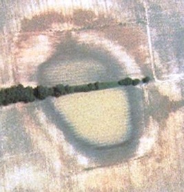
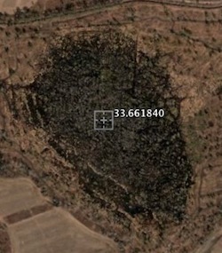
Here are a few photos showing this very common compressional artifact.
Other supportive details include the well-understood fact that, universally, the soil layers containing the bays are superimposed on underlying strata at a sharp and "abrupt comfortable" interface that shows no interbeding.
Much of the current research identifies the strata as consistent across wide areas, both within single and multiple bays.
No variation in the heavy mineral suite was found along a traverse of the major axis of one South Carolina bay; even though samples were taken from the bay floor, bay rim and the adjacent non-bay terrace (Preston and Brown, 1964).
Our conjecture holds that a major component of the ejecta slurry was terrestrial strata from the Michigan Basin area. This quote from a web page at Clemson University makes some interesting comments:
While the surface color can be bright enough to appear almost white, the color of the "B" horizon layer is often brown or black, like topsoil, but it is found about four feet below the soil surface. [Soils of this type are usually found in northern regions, like New England, Northern Michigan, Minnesota, and Canada.] For several reasons, including acidity and possible aluminum toxicity, this is not a good soil for plant growth and is only sparsely covered by scrubby pines, blackjack oak, and turkey oak.
In the following photograph, courtesy of George A. Howard, shows a large cross-sectional cut into a Carolina bay rim. In our view, the strata" represents a very tortured and gnarly configuration. This is more representative of a metamorphic strata than one created by common soil layer mechanisms.
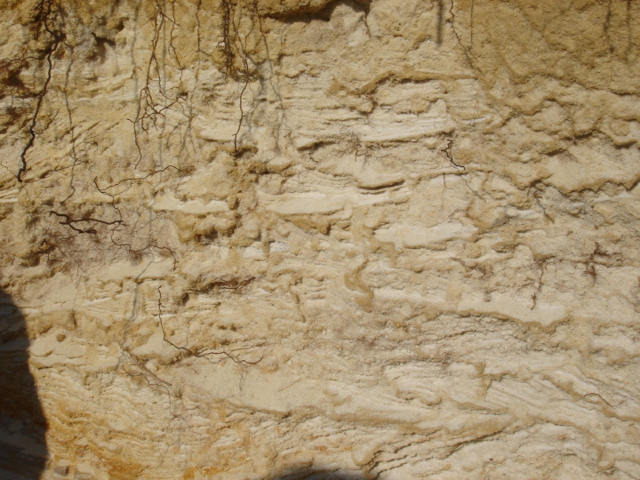
When presented with the ejecta strata concept in 2006, noted soil geologist R.B. Daniels observed that the conjecture, while hard to embrace, did address one ongoing enigma of the bays (and Goldsboro Ridge in particular): The unconsolidated deposits that constituted the rim bays did not contain the lenses of clay that would be expected in a classical fluvial deposition mechanisms.
"Carolina bays" are not existent only on flat landscapes. The Goldsboro Ridge Structure includes several clearly delineated Carolina bays within the ridge itself.
In addition to the classic bay structure, we have identified numerous ejecta placements to the west of the Michigan Basin that exhibit a classic Carolina bay formation.
Nebraska Bays
Users of Google Earth can review the full of then initial set of Distal Ejecta Deposit fields by downloading this kml file:
(1) A RE-EVALUATION OF THE EXTRATERRESTRIAL ORIGIN OF THE CAROLINA BAYS by J. Ronald Eyton & Judith I. Parkhurst

Geological Research by Cintos is licensed under a Creative Commons Attribution-NonCommercial-ShareAlike 3.0 Unported License.
Based on a work at Cintos.org.
Permissions beyond the scope of this license may be available at http://cintos.org/about.html.